

Mexico

Red brick buildings are mostly concentrated in the states west of Mexico City, specifically Jalisco, Michoacan, Guanajuato, and Aguascalientes.

White concrete block buildings are highly concentrated in the states surrounding Mexico city, and are generally more common to the east. They can however still be found all over the country.

Mud brick buildings are most abundant in Durango, especially full houses constructed with mud brick. However, they can essentially be found in almost all of the dry desert states.

Architecture in northern Mexico often features design elements from American style bungalows. Many houses are coloured with light or pastel colours, gated and commonly have front yards. Orange tiles inspired by Spanish colonial architecture are also typical.

Thatched roofs are most common in the Yucatan peninsula and eastern San Luis Potosi. They can also be found elsewhere, mainly in the southeast.

These walls made of light coloured rock are found in the Yucatan peninsula, but most common in Yucatan state.

A thick cross can be seen on the back of signs in Chihuahua.

Bollards with a red band near the top are unique to Nayarit, apart from one exception being Federal Highway 190 on the Oaxaca-Chiapas border.
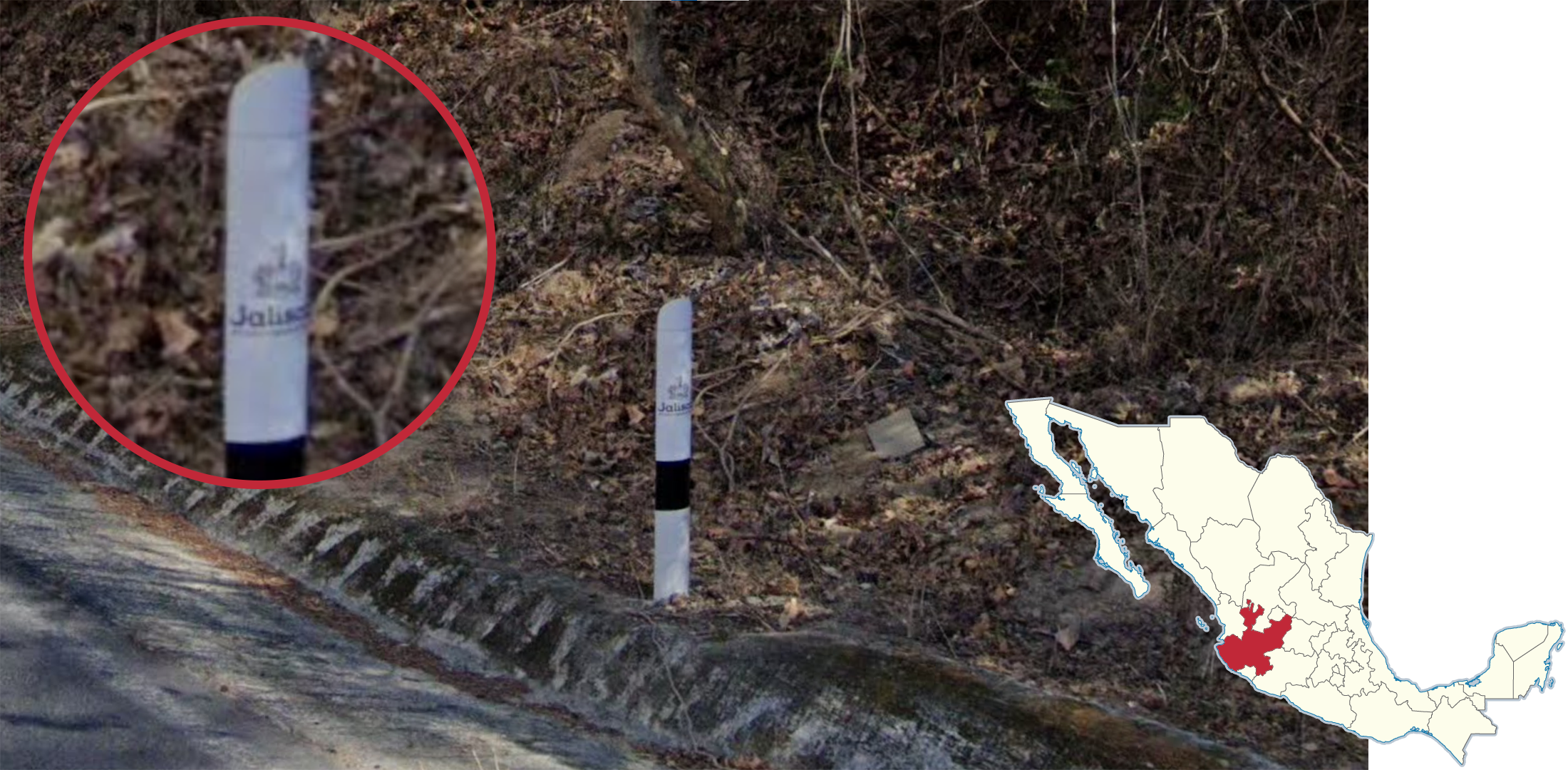
Jalisco bollards will sometimes have a crown and the text ‘Jalisco’ written on it. These are usually barely legible unless very close, however no other Mexican bollard will have writing on it.

White insulators that are shaped like acorns can be found along the coastal states of Mexico, but are by far most common in Michoacan, Colima, and Veracruz.

Poles with an asymmetric crossbar and double-stacked insulators are exclusive to Mexico City, State of Mexico, Hidalgo, and Morelos.

Wooden poles with a lowered crossbar are mostly found in Sinaloa and Sonora.

These concrete poles with insulators suspended below the crossbars are unique to the Yucatan peninsula.

The wooden variant of the hanging pole is found on the Baja California peninsula.

Poles with a lowered crossbar and a single support beam that extend from one end of the crossbar to the pole itself can be found in Durango.

Poles with a mesh body are most commonly found in San Luis Potosi, Guanajuato, and Queretaro.

White middle roadlines are most commonly found in Tabasco.

These fences made out of trees with red-coloured bark are commonly found in Veracruz.
NOTE: These tree fences can still be found in other coastal states and are best utilised when combined with other clues.

Black tar on both sides of the yellow centre line can be seen in Sinaloa, Durango, and Guerrero.
NOTE: This is most reliable when the tar is not faded.
Grainy pavement with a blue-ish grey tinge is a common sight for the states of Tamaulipas and Nuevo Leon.
NOTE: In Tamaulipas, larger roads very commonly feature dashed outer lines.

This style of cobblestone pavement, unorganised with irregular tiles, can be found in most of the central states, but is by far most commonly found in the states of Nayarit, Jalisco, Colima, and Queretaro.

This pavement consisting of hexagonal tiles is found in Puebla and Tlaxcala.

This exact pavement design with three lines of cobblestone patterning is exclusive to Oaxaca.

Taxis in and around Mexico City have a white lower half with a pink upper half.

The area around Mexicali features flat farmland with a ridge to the west. Washingtonia palms are very common and these poles made out of brown wood can be found.

The area around Poza Rica in Veracruz features a lot of citrus tree plantations. It is common to see large amounts of these trees grown right on top of the hills.

The area around Ciudad Obregon is distinct due to the pinkish-tan soil and canals found around the city’s agricultural areas.

The twin volcanoes of Iztaccíhuatl and Popocatépetl are found on the border between the State of Mexico and Puebla. Keep in mind that they are usually much less visible than depicted in the image, which is just for reference.

Cerro del Bernal is a distinct extinct volcano that is found in southern Tamaulipas. It can be found heading directly northwest of Tampico or west of Morón.

This extremely long and flat ridge is found in the Sierra del Abra Tanchipa Biosphere Reserve in eastern San Luis Potosi.

This tall, flat ridge, with very prominent ridgelines, belongs to the Maderas del Carmen Biosphere Reserve in Northern Coahuila near the US border.
NOTE: The only road the mountain range can be observed from is the Federal Highway 53 that leads to Boquillas del Carmen.

The outskirts of Ciudad Juárez features a lot of dirt roads with a distinct shade of orange soil and low shrubs.

The area around San Cristóbal Suchixtlahuaca and south of it in Oaxaca often feature rolling hills with really distinct orange and beige-tinged soil, passing from one colour to the other with each hill. The beige-tinged soil can be seen more prominent in some locations.

The town of Guaymas has a lot of jagged cliffs and mountains that make the area very distinct. The soil is also distinctly pinkish and organ-pipe cacti can be seen scattered on the hills and next to the road.

The town of Los Coloradas is famously known for the pink lakes around the area.
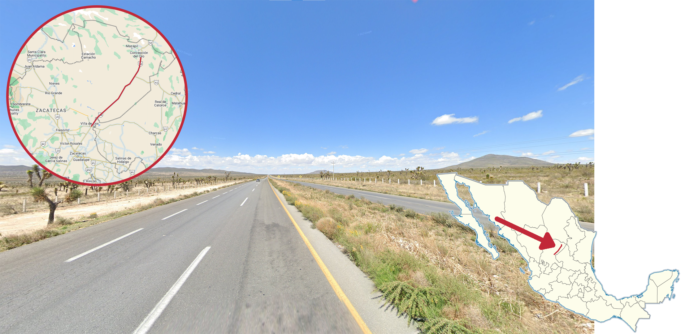
The 54 is a divided highway that runs through northeastern Zacatecas which features yucca trees spammed on both sides of the road. Additionally, the streetview car is often exposed and appears almost white due to the sunlight.

The 40D that crosses the Sinaloa-Durango state line is recognizable by the stunning lush cliffs and mountains along the road. The highway commonly passes through tunnels and the road itself features double yellow middle roadlines.

This road divider with a yellow top and bottom edge is found all along the 95D from Mexico City to Acapulco.

The Eurus Wind Farm is located in southeast Oaxaca and is the largest wind farm in Mexico. Rows of wind turbines can be found along the 190 around Juchitán de Zaragoza.

Most lamp posts and lamp arms in Aguascalientes city are yellow.
NOTE: They are not exclusive and are only very common.

This lamp with a black rectangular head is found in Cuernavaca.

This lamp with black front and back edges and a white middle section is found in Santiago de Queretaro.

This lamp with five circular bulbs that looks like a dice is found in Cancun.

This lamp with a rectangular head and a ring-shaped light bulb is found in Matamoros.

This lamp with a zig-zag bent pole arm is found in Hermosillo.

The bottom half of poles in Cuernavaca are often painted green.
NOTE: In Generation 4, the paint usually looks faded, some to the point where it is barely visible.

Poles in Chihuahua city occasionally have a strip of white pole paint with the street name written in black or blue text.

This Street View car with a yellow hood can be found by the La Malinche volcano in Tlaxcala.

This white truck with visible rearview mirrors can be seen in the Cofre de Perote national park.

This red Street View car with a black roof can be found in the town of La Seca in Sinaloa.
GeoGuessr’s own official maps are not very good, for a variety of reasons. Plonk It recommends the following maps instead: