
Beginner’s Guide to Geoguessr
While Geoguessr once was just a fun novelty game to pass the time, it now has a strong playerbase that spends a lot of time practising and researching in order to make the best guesses possible. This can make learning Geoguessr seem like a daunting task, particularly since most popular content creators are very experienced players that frequently use very in-depth and obscure clues.
However, it is not as hard as it may seem to get into Geoguessr. Using the proper tools, anyone can have fun and be competitive in this game. With this guide we aim to make the learning experience as accessible as possible. To help newer players, we will introduce the game mechanics and different gamemodes. After that, we will explain the ways in which experienced players manage to achieve great guesses based off of seemingly very little information. Finally, we will outline the tools and practices that we recommend for practising effectively.
There is a Glossary at the end of this guide containing many Geoguessr-specific terms that are frequently used in the community.
Game mechanics
In game
When you load into a round of a singleplayer game, you will see the interface pictured below.
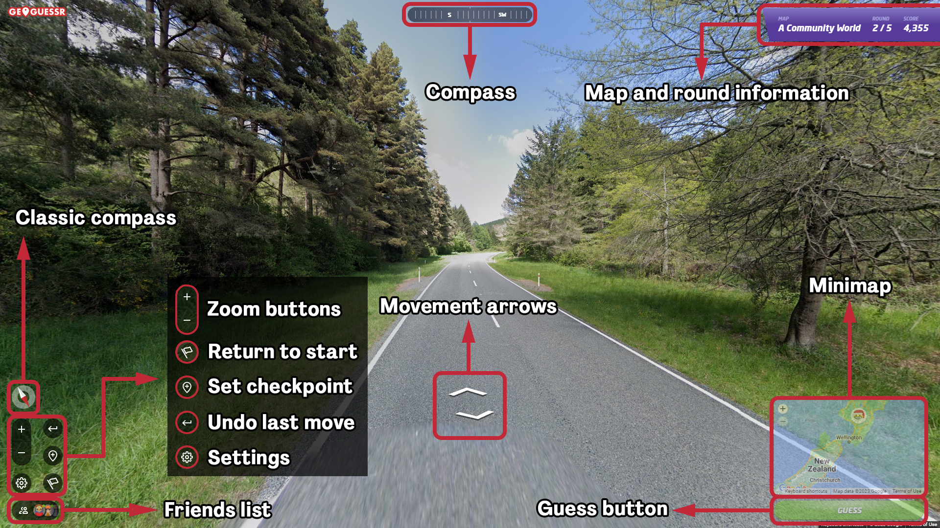
The interface of a classic game of Geoguessr with moving settings.
In a moving game there are several techniques for moving around. The most common is to click on the road in the direction you want to move towards. You can also use the movement arrows at the centre of the screen, these are particularly useful in rounds where the movement does not work properly. Finally you can also use the letters W and S to move forward and backwards respectively. You can use the arrows or the keyboard keys when you want to move with precision one panorama at a time.
You can pan around by clicking and dragging the mouse and zoom in and out with the scroll wheel. Alternatively, you can use the zoom buttons in the bottom left. It is also possible to pan with the A and D keys, as well as the right and left directional arrows.
In moving games you also have a few useful buttons in the bottom left. The “Return to start” button (hotkey R) sends you to the initial location of the round. This is a very important tool in moving games since you need to guess the initial location, not the one you are on when you make the guess. The “Set checkpoint/Return to checkpoint” button (hotkey C) allows you to set a checkpoint at a location you have moved to, press the button again to return to the checkpoint. The “Undo move” button (hotkey Z) sends you back to your previous location after moving. This is especially useful when you accidentally move from a main road into a side road and it would be time consuming to go back with the normal movement.
Hovering over the minimap opens it in a bigger size and you will see three new buttons on the top left, two arrows and a pin. You can use the arrows on the top left to resize the minimap. The pin button locks the minimap so it does not minimize after moving the mouse away.
When you are ready to make your guess you can use the Guess button or press space to lock it in.
The Compass
The compass is one of the most important tools in order to properly pinpoint a round. Knowing the direction of a coastline, a mountain range, or a city skyline are very basic ways to make an educated regionguess, and knowing the exact angle of the road you are on is often crucial for finding the 5k.
By default you will have the compass at the top of your screen, this compass is centred on the direction you are looking towards. You can turn on the classic compass in the settings menu. In the classic compass the red arrow points towards north and the white one towards south, relative to the direction you are looking at. When you look directly east, the compass will be perfectly horizontal with the red arrow pointing left. Which compass to use is a matter of personal preference.
It is important to mention that some images in this guide have been modified in order to show both compasses at the same time.
A common technique to find the road angle is to look straight down with the compass pointing exactly north. Then the road on the map should be parallel to the direction of the road you see on your screen. The roadlines are usually the easiest way to compare the angle.

An example of lining up the road in Uruguay.
This technique can also be used to find plausible roads or sections of road in a region if you do not know exactly which road you are on. Highways or coastal roads are some examples of locations where looking for the right road angle can lead to very close guesses.

In this round there is information to know you are between the cities of La Paz and Oruro in a big divided road. With the road angle you can make an educated guess that you are likely in the green section, with a chance of being somewhere in the yellow section. You can discard the sections highlighted in red because the angle of the road is very different.
The map
In the Geoguessr context, a map is just a collection of locations published in the form of a playable map. Every gamemode, including those that do not specify it, uses locations exclusively from one map at a time.
Geoguessr’s own official maps are not good for a variety of reasons. One of the most common complaints being how some small areas often are extremely over-represented in the official maps. Locations such as the Midway Atoll come up more often in “World” than entire countries. Luckily there is an active map making community that is constantly producing and updating high quality maps that we recommend playing instead.

This corner of the Midway Atoll runway is one of the best known locations in the game due to it being extremely over-represented in Geoguessr’s official “World” map.
To this effect, we released the Plonk It Map Directory, a page where we recommend the best maps to play in a variety of categories, ranging from general gameplay to themed and novelty maps, with short descriptions to help you find maps that fit your needs.
Finding maps within the Geoguessr website is also possible, the Community Maps page hosts the most liked and played community-made maps, as well as recently popular and new maps.
It is important to mention that the Geoguessr map maker does not allow users to manually select more than 135,000 locations. When you encounter maps with more locations than that, it means the map has been made using the polygonal tool in Geoguessr’s own mapmaker. This tool yields low-quality maps, and therefore we strongly recommend not playing these.
There are some concepts that show up in the Map Directory as well as in map descriptions that are not necessarily intuitive:
Pinpointability: Pinpointable maps are those where every location is placed on a distinct map feature, such as an intersection or a bridge, so that you can achieve a perfect score in every round if you put in the effort. Non-pinpointable maps may have locations in long straight stretches of road or sections with broken coverage, making it impossible to make accurate guesses in some rounds. We therefore recommend using pinpointable maps for moving games.
Handpicked/Arbitrarily generated: Handpicked maps are those in which every location has been selected by the mapmaker. In arbitrarily generated maps, locations are chosen by a computer program according to parameters established by the map maker. Arbitrarily picked maps frequently use the term “AI Generated”, although there is no AI involved, just regular computer algorithms.
Distribution: How to distribute locations between countries and regions is a topic of debate among the map making community. Things such as country size, coverage density, and diversity of landscapes are commonly used to determine how many locations a country has in a world map. A balanced distribution usually means that big countries are somewhat under-represented relative to their size, and small countries and territories are overrepresented in order to increase variety between rounds.
Official/Unofficial coverage: Geoguessr is based on Google Street View; therefore, the term “official coverage” refers to imagery released by Google themselves. There is also privately published imagery in Google Maps; this is referred to as “unofficial coverage”. This includes photospheres, which are 360 degree pictures typically taken with a cellphone. You can also encounter unofficial car coverage (“Ari”) taken in a way similar to Google’s own coverage, but usually with much lower image quality. Competitive maps will always feature exclusively official coverage.
Pinpointing a round
Pinpointable maps are those that have every location close enough to a distinct feature on the map so that a perfect score is achievable in every round. This does not mean that the information will always be visible from the starting location; moving around may be necessary in some rounds to get a perfect score.
The most common “pinpoints” in maps are intersections, the middle point between two bends in the road, bridges, and railroad crossings.
In urban rounds, street names will be the most common way to pinpoint a location. Business names and other points of interest can be unreliable, especially outside of developed countries, and while they can be used to pinpoint some rounds, they will rarely be the intended way to solve a round in a pinpointable map.
An example 5k in a pinpointable map.
In more rural rounds, there will sometimes not be any written information to confirm the pinpoint, and the player needs to use a combination of moving around to find information about the region, and using the compass and the environment to form a mental image of how the round looks like in the map.
Finding directional signs towards nearby towns or cities, as well as finding road numbers are some of the most effective strategies towards nailing down the possible area where a round can be.
Scoring
The score you obtain in a round of Geoguessr naturally depends on how close or far away you guess from the correct location. However, there are some technical details that are important to know.
First of all, the scoring is not linear, instead, the score drop-off is exponential. This means that the same distance will have a bigger impact on the score the closer you are to the location. Being 30 km away in a world map loses you roughly 100 points, but the difference between being 1000 and 1030 km away is less than 50 points.
There is also a parameter based on how much ground the map covers. This means that maps of singular countries have much harsher scoring than world or continental maps.
Guesses below 25 meters will always net a perfect score in every map. The perfect score radius gets bigger with the size of the map, going up to a range of 140 to 200 meters in world maps.
One last detail that is worth remembering, is that due to the Mercator Projection used on the minimap, distances will be exaggerated towards the poles, and will conversely be bigger than they appear close to the Equator.

The equation used for calculating the score. “Distance” naturally refers to the distance between the guess and the correct location. “Max Distance” is the diagonal of the smallest rectangle possible that would contain every location in the map.
Coverage Map
Since the game is based on Google Street View, the countries that show up will correspond to the countries covered on Street View. Knowing what countries have coverage and which ones don’t is a basic piece of information to have, since there are some areas of the world, such as Africa and central America in which only a few countries will appear ingame.

You can click on this image to enlarge it. This map is up to date as of April 2024.
You can check the extent of the Street View coverage in this website.
Frequently Asked Questions
You can find more information about related topics in Geoguessr’s Frequently Asked Questions page.
Gamemodes
There is a variety of ways of playing Geoguessr. From taking as much time as you need to get the exact location of a round in a moving game, to trying to guess the right country in 0.1 seconds but the screen is scrambled, upside down, and in black and white, there is a gamemode for everyone.
In the settings screen of a classic game you will find these four options if you turn off the default settings.
Round time: You can use this setting to introduce a time limit to your games.
Move: This settings controls whether you can move in the game or not. To move, you can click in the distance in the road, click on the two directional arrows you will see at the bottom of the screen, or press the keys “W” to go forwards and “S” to go backwards (in a QWERTY keyboard).
Pan: This settings refers to whether you are allowed to pan around and see your surroundings. You pan by left-clicking with your mouse on the image and moving it around while clicked.
Zoom: This setting controls if you are allowed to zoom in and out. You can do so with the scroll wheel of your mouse or the “+” and “-” buttons found in the bottom left of the screen. The Pan and Zoom settings are almost exclusively linked, as playing with zoom but not pan enabled or vice versa leads to somewhat wonky gameplay.
Single player games
Geoguessr players often talk about three different main gamemodes.
Moving games: The objective of moving games should be to get a perfect score (casually known as a 25k) and they should be played on pinpointable maps. Sometimes these games are played with a limited amount of time, like on Geoguessr’s official Daily Challenge.
No move: This is the most common gamemode for country and region streaks, although people also attempt to get highscores and even perfect games using this setting.
NMPZ (No moving, panning or zooming): In this challenging gamemode all you get is a single image. Good maps frequently pan locations away from car meta, so countries that are usually recognized by the Google car offer a new challenge.

The settings page of a single player game. In the picture we can see the settings for a No move game.
We can also categorize Geoguessr gamemodes depending on the objective of the game. In this context, these gamemodes are the most common.
25k speedrun: This refers to attempting to get a perfect score on a specific map as fast as possible, usually in a moving game.
Highscore games: Attempting to get as high of a score as possible in a No move or NMPZ game. Sometimes time limits are introduced, such as 10 seconds NMPZ which is a popular category.
Country streaks: Guessing the right country as many times in a row as possible on a given map, this gamemode is played both No move and NMPZ. While Geoguessr has their own Streaks gamemode, it is limited to only a few maps and does not allow regionguessing within countries. Therefore, community-made scripts are normally used to keep track of the streak. Country Streaks are by far the most popular Plonk It record category.
Region/Subdivision streaks: In many countries (usually the bigger ones) people play streaks trying to guess the right subdivision.
Hedge streaks: This gamemode combines the skills from both highscore and country streaks. It is based on achieving as many games above 20,000 points in a row as possible. While you can afford to guess the wrong country in the middle of Europe, it becomes necessary to get the right region in big countries like Russia and Canada.

World Cup contender zi8gzag’s first 100+ streak in A Diverse World ended on one of two spill locations in Paraguay, a country that does not have official Google Street View coverage.
Cooperative games
Many Geoguessr gamemodes can be played cooperatively.
Streaks and highscore games can all be played in cooperative. Whether it is playing in the same room on one computer, sharing screen over a voice call, or helping out in a Twitch stream, working together to solve a hard round is always fun.
Bullseye is an official multiplayer mode in which 2-6 players work together to get as many points in a 5 round game. Each player can use a circle and the game will tell you if the location is inside it or not. The smaller the circle, the bigger the points, and if you manage to find the exact location, you can use a bullseye circle to get a perfect score.

An unfortunate round of Bullseye.
Making and playing in a Party
From the main menu, you can click the Party button in the left to create a Party lobby. From here, you can select a variety of gamemodes to play. Once the gamemode has been selected you can change the settings. There is some general settings, like changing whether chat is enabled, or if you want to make the party public, and some gamemode specific settings, such as round time, moving, panning or zooming, Battle Royale Power Ups, etc.
Public parties can be found in the Community page, if you choose to make your party public it will appear here.
The host of the party can share a link to join the party, or a 4 digit alphanumerical code that you can enter in this page.
While only Pro users can host parties, people without a subscription can play in party games without a time limit, so this can be a great way to introduce Geoguessr to friends and family without them needing to commit to a paid subscription.
Competitive games
Competitive Geoguessr is mainly played in the “Duels” format, but they can be played on different settings. There are also some other competitive gamemodes. In the Multiplayer section of the Geoguessr website you can find the following gamemodes.
Duels: In a duel both players start with 6000 points of health, and play the same rounds. After one player guesses, the other has 15 extra seconds to guess. After that, the difference in score is dealt as damage to the health of the player that guessed furthest away. Starting in round 5 multipliers start. This means that the damage dealt is multiplied by a factor, increasing by 0,5 per round. In Official Duels the games are played on a moving format. Below the Gold Division, the map is the Geoguessr “World” Map. Duels in the Gold, Master and Champion divisions are played on a community-made map such as A Community World or An Official World. After reaching the Gold Division, players unlock No Move duels. Players in the Master and Champion Division have access to NMPZ duels.
Battle Royale Countries: In this gamemode you have 3 attempts in each round to guess the right country. The last person to guess the right country on each round (or everyone that did not manage to do so) gets eliminated until there is only one remaining. The game is played in a moving format, with a maximum time limit of a minute and a half. During the first 15 seconds you can “lock in” your guess, if every players locks in the right country they all go through to the next round. This gamemode is found in the Unranked part of Multiplayer.
Battle Royale Distance: In this gamemode you have a minute to guess as close as possible to the location, the person furthest away each round gets eliminated. You can have up to 3 guesses, but to regain two of them you need to guess in the right country and within a certain distance of the location. This gamemode is found in the Unranked part of Multiplayer.
Team Duels: Play a casual unranked game of duels with a friend. Due to the lack of matchmaking we recommend playing Plonk It 2v2 if you are interested in a competitive team duels experience. You can communicate through in-game chat with your teammate.
In Plonk It, we host a variety of competitive gamemodes and have our own Ranked Leaderboard. You can click the link to learn more.
1v1: In this gamemode you play a challenge link (the same 5 round game of Geoguessr for both players) and whoever gets the higher score wins the match. You can set your preference to only playing No move games, only playing NMPZ or either.
2v2: Play a No move 2v2 duel with a friend or let the matchmaker find you a teammate.
BO3: Emulate the format of the Geoguessr World Cup in this best of 3 gamemode where you go head to head in moving, No move and NMPZ games.
But wait! There is more!
Chatguessr is a tool used by Twitch streamers to host games of Geoguessr and allow their viewers to send their guesses through a website. It is customary to allow the winner of a game to choose the map for the next one.
Live Challenges is an official gamemode that can be used in parties, up to 100 players can play the same 5 round seed of Geoguessr. Streamers sometimes organize lobbies of this gamemode, and every now and then there are Live Challenges tournaments.
Community tournaments take place every week, from casual tournaments mostly for fun, to prize money tournaments where you can find many top players. Community organized tournaments are the best way to get into the most serious side of competitive Geoguessr. Tournaments are usually played as team duels in a variety of different maps.
A tournament moment from The Geo Special tournament that takes places twice a week.
Official Ranked Leaderboard
Geoguessr hosts its own competitive leaderboard. You can climb it by playing any of the three ranked gamemodes: Duels, No Move Duels and NMPZ Duels. The rating works with an Elo Rating System. When you play lower rated opponents, you put more of your points at risk, and vice versa against higher rated opponents. New accounts start with a rating of 500.
You can check the latest information about the official ranked gamemodes on this page.

The results of the Harvest Season, the last season of 2023. This season was uniquely played on the same map as the 2023 World Cup. After 8 weeks and 160 games, Jake Lyons took the victory by a thin margin over second place. In that season Battle Royale Countries and Distance were ranked gamemodes. They have now been replaced by No Move and NMPZ Duels.