
Kazakhstan


When blurred, the standard Kazakh licence plates are mostly white, with a small hint of blue on the left side.

Kazakhstan uses both Cyrillic and Latin alphabets.
Though sometimes, Russian is used monolingually.
The following letters are found in the Kazakh but not Russian alphabet: Ә (Ä), Ғ (Ǵ), Қ (Q), Ң (Ń), Ө (Ö), Ұ (W), Ү (Ü), Һ (H), І (I).
Kazakh is related to Turkish, so the Latin text can appear similar.

All of the coverage in Kazakhstan was taken with a white pickup truck, which can either be fully visible or mostly blurred.

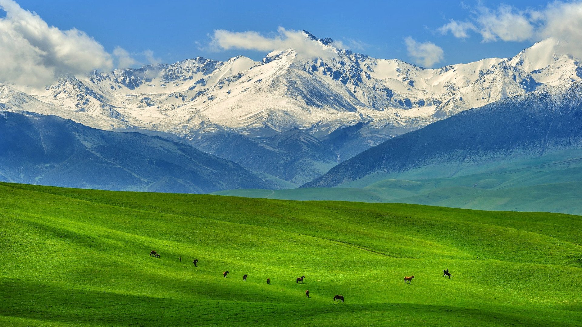
Kazakhstan is a big and diverse country, which features a plethora of distinct landscapes like deserts, grassy steppes, mountain passes, and birch forests.
Most strikingly, most of the rural coverage in Kazakhstan is in a very empty, open and mostly flat landscape.

A lot of Kazakh infrastructure, from pedestrian signs, poles, houses, to bollards, is very similar to what you see in Russia.

Like Russia, Kazakhstan uses yellow and white stripes on their pedestrian crossings. However, unlike Russia the stripes often have white dashes on either side. Sometimes, you can find the dashes without the stripes.

Street Signs in Kazakhstan are often attached to buildings and are blue in colour, with white intricate patterns on the top and bottom. They are usually bilingual or trilingual and can also contain a QR code.
NOTE: They are often inconsistent, with many designs being found in a single city.

Kazakhstan uses a variety of post-Soviet style bollards, as well as ones that resemble Turkish bollards. Notably, the bollards seemingly consisting of two thin bollards attached at a 90° angle are unique to Kazakhstan.

The bottom of tree trunks are very often painted white.
NOTE: This is common in several eastern European countries, as well as in parts of Russia.

Unlike neighbouring countries, Kazakhstan primarily uses yellow and black chevrons, except on T Intersections, where you will find the more generic red and white chevrons.

Gas pipes are extremely common in Kazakh cities.

This ornamental pattern known as the koshkar-muiz can be found as part of decorations in all kinds of settings in Kazakhstan.

Many cities and towns in Kazakhstan have these entrance arcs, which are often quite intricate and ornate.

Coverage in Kazakhstan is fairly limited. While most major roads and cities are covered, coverage on small rural roads is fairly uncommon. As such, knowing which roads have coverage can help narrow down the guess.

Kazakhstan can easily be divided into coverage regions based on the season.
Summer in western and central Kazakhstan.
Autumn in the northeast.
Winter in the southeast.

Driving directions can help you narrow down your options when you are on a rural road.

Kazakh area codes are useful to learn, and they generally follow an east to west pattern along three horizontal lines.

You can occasionally spot licence plate codes on the back of trucks and buses. The codes themselves follow an alphabetical order, with smaller numbers corresponding to regions that start with earlier letters. Note that cars do travel, and as such not all codes are reliable. Buses and smaller utility vehicles are the most reliable.

While rarely possible, being able to read the letters under a QR code on a street sign will give you the region.

Kazakhstan is a generally flat country, so getting locations that are hilly or mountainous are useful for narrowing the options.
For example, the region around Karaganda is often either quite hilly, or you can see hills in the distance.
Another notable set of hills would be the ones around Aktobe.
And of course getting bigger mountains will mean you are in the south, or east.

These lush birch forests next to green fields are common in northern Kazakhstan.
NOTE: This landscape often appears very similar to that found in and around Omsk Oblast in Russia.

Vast grassy green plains are found in northwestern Kazakhstan. They are especially common in Akmola and Kostanay regions.

Sandy and shrubby desert-like landscapes are common in southwestern Kazakhstan.

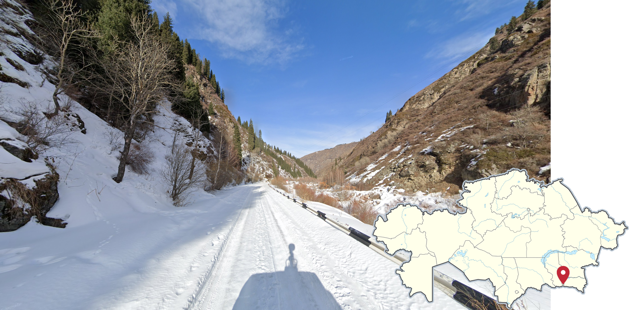
Tall mountains, which are often snow-capped, can be seen in southeastern Kazakhstan.

The East Kazakhstan Region is hilly and forested. It was covered in october, so you will see fall colours on the vegetation. The town of Ridder itself is flat, but surrounded by hazy mountains.

Snow coverage can be found in southeastern Kazakhstan, especially east of Almaty.

The landscape in southern Kazakhstan near Uzbekistan is hilly and quite dry and shrubby, with a lot of orange looking grass. The landscape consists of dry but grassy rolling hills or dead flat agricultural land near Zhetisay.
NOTE: These red and white KM markers that look like Kyrgyz ones, are only found near Zhetisay.

Grassy green rolling hills can be found in southern Kazakhstan. They are especially common just north of Bishkek

Around Semey, you can find small clusters or entire forests consisting mostly of pine trees and some deciduous trees, which will have fall colours.

The divided section of the E38 goes southeast to northwest from Shymkent to Kyzylorda. The road is made of asphalt, and it has all white road lines. The landscape varies quite a lot; in the south, it is very green and in the north, it gets dry, sandy, and shrubby.
Driving direction: Both ways

The section of the M36 going from Karaganda to Almaty can often be recognised by the road being under construction, with a second lane being built. Yellow lines are common. As for the landscape, it’s a wintery dry steppe, which looks noticeably orange-brown.
Driving direction: South from Karaganda.

Between Karaganda and Astana, the M36 is now a divided highway, with yellow outer lines. The landscape consists of a grassy, sometimes hilly, steppe with an occasional row of trees along the road. Note that the general southeast to northwest road angle is important.
Driving direction: Both ways

The P4/A17 from Astana to Pavlodar is a divided road, generally going east to west, through a hilly steppe landscape similar to the M36, but is generally less vegetated. Most of the road has outer yellow lines.
Driving direction: Both ways


The A26 goes from Kandyagash to the intersection of M32/E38.
It has very bad road quality throughout, ranging from poor grainy pavement, to completely unpaved. Apart from the northernmost section, the weather is either cloudy or overcast.
The landscape consists mostly of flat, semi-arid grassy plains.
Driving direction: North towards Kandyagash. (Mostly)

The section of the A1 going from Astana to Shchuchinsk is a 6-lane divided highway. The landscape around is generally quite green, with trees and grassy plains or hills.
Driving direction: Both ways

The A17 going to Ulytau Region can be recognised by the bad pavement quality, where the edges of the road are almost crumbling away, along with the single white middle road line, which can be dashed or solid. The landscape itself is a grassy steppe, with some fall coloured trees occasionally lining the roads.
West of Atasu, the sun is distinctly low on the horizon.
NOTE: A small section east of Atasu has pristine new pavement, which has a slight red tint to it.
Driving direction: Towards Atasu from both directions

The road north of Zhezqazghan has no road lines. The landscape is very dry, desolate, with very limited vegetation and slightly hilly. The soil can look very red or orange at times.
The weather is sunny, with a lot of cumulus clouds.
Driving directions: North from Nikolskiy

The R260 road is mostly paved, but not in the best condition; many cracks can be seen, and it mostly lacks road lines. The weather is overcast and the landscape is a slightly hilly steppe, consisting of somewhat yellow grass and reddish soil, which is very evident when the road is unpaved.
The R217 is very similar, but the road is in better condition and mostly has very faded dashed white middle road lines, which are often quite difficult to see. The further east you go, the more sparse the cloud cover gets.
Driving directions: South from Atbasar

These regions/cities have the most useful pole paints you can learn.
The descriptions will be written from top to bottom:
West Kazakhstan Region uses red, white, and black paint.
Atyrau Region uses blue, white, and black paint.
Akmola region has a very thin layer of red, then white, and a thin layer of black on the bottom.
Kostanay uses a thin layer of turqoise, and yellow.
Petropavl has a thin layer of white, and light grey.
Taraz has red, yellow, and black.
Kyzylorda poles have a thin layer of yellow and red, then white.
Kyzylorda lamp posts are white, and have turquoise on the bottom.

These pole paints are less useful than the above hint, but still worth learning if you want to master Kazakhstan.
The descriptions will be written from top to bottom:
Rudny has red, yellow, red on the top, with white below it.
Kokshetau uses a few designs, but they all have light blue on the bottom, and sometimes, a thin strip, or two, of yellow on top.
Shchuchinsk has a thin layer of red, and yellow.
Ekibastuz has a thin layer of blue, and white
Shymkent poles have a thin layer of yellow and red, then green.
Kentau poles have thin layers of blue, yellow, and red, then blue and black below them.

These are the most useful to learn bus stops.
Atyrau has a modern design, with white and lime/neon green walls. The bus stop name is prominently written on top.
Kostanay uses simple brown bus stops, that have a blue and yellow crest on one of the glass panes.
Petropavl also has brown bus stops, with glass panes on all 3 sides not facing the road. The roof is angled slightly upwards.
Karaganda uses old looking turquoise bus stops, which have a curved roof.
Zhezqazghan has very wide blue bus stops, which have 2 sections; 1 indoors, and one outside. These sections are separated by a door.

These cities have buses worth learning.
Aktobe uses orange and black buses.
Zhezqazghan has orange and white buses, with “Men ♥ Jezz/Zhez” written on the sides.
Astana commonly uses these white, black, and green electric buses.
Karaganda uses turquoise buses, just like their bus stops.
Semey has these light green and white buses.
Almaty uses fully green buses, with white patterns and the city name on the sides. Taraz can use similar buses, but they will have “Taraz” written on the sides instead.

These street signs attached to buildings are generally quite inconsistent, but there are some worth knowing.
Aktobe has compact signs where half of the space is taken by the QR code.
Petropavl uses white signs, with a blue semicircle below the street names.
Astana consistently uses this fairly generic design.
Zhetisay also uses a fairly generic design, but it is not found in Turkistan or Shymkent.

Yellow boxes connected to the gas pipes are common outside houses in Shymkent, Turkistan, and Taldykorgan.
Turkistan consistently uses these thin grey lamps with two small light sources near the end.

Lamps in Kulsary have a sizable blue photocell on the top.

Some lamps in Uralsk have this very unique design, with 3 separate lamps in an ascending pattern.

A visible wire in the back of the Street View car can be found in all of western Kazakhstan.

This combination of 3 dots; 2 of which are close together near the back of the roof, and a third one above to the left, can be found in the coverage north of Zhezqazghan, but not in the city itself.

Around Kyzylorda, there is another combination of 3 dots; one on the bottom right, and 2 dots side by side, closer to the middle.

On the P24 between Oskemen and Semey, as well as in both cities, you can spot this “zigzag” shaped smudge on the left side of the car.
NOTE: The smudge is highlighted in the image, and will not appear pink on street view.

In the highlighted coverage east of Almaty, the back of the roof is very dirty.
NOTE: Similar dirty cars can be found in some nearby cities.

Between Petropavl and Kokshetau, there is a small smudge slightly to the left on the bottom of the roof.

Between Kokshetau and Atbasar, the car has a thin coating of dirt and dust, which is most visible near the back of the roof.

East of Aktobe, there is a vertical line of dirt on the right side of the roof.

South of Beyneu, there is a faint dot on the middle-right of the roof.
NOTE: This dot along with other smudges can be found in some nearby cities.

Coverage in dense baltic pine forests can be found north of Shchuchinsk, which is north of Astana.
NOTE: Baltic pines can be found in other parts of the country.

Parts of Oskemen have hazy forest fire coverage.
In southern Almaty City, there is snow coverage in the mountains.

The Altyn Emel National Park is a barren grassland with snowy mountains in all directions. Some parts are very snowy. And in the eastern section, there is a small curvy mountain pass.

The only May coverage in Kazakhstan is found in the Almaty exclave of Alataou, which is east of Almaty proper. All of the coverage is sunny and the mountains are visible to the south.

A small ridge of hills is visible to the north in a lot of Taldykorgan coverage.

Near the Turkmenistan border in southwest Kazakhstan, you will find this unpaved sandy desert road. The landscape is almost blindingly bright from the sand.
GeoGuessr’s own official maps are not very good, for a variety of reasons. Plonk It recommends the following maps instead:
A Diverse Kazakhstan (map link) - The map has over 53,000 locations evenly spread across the country with a good urban/rural balance.
In addition, here are some resources to help you practise Kazakhstan:
Plonk It Kazakhstan (map link) - This map contains locations for practising each meta in the Plonk It Kazakhstan guide from step 2 to 3.