
Bolivia


Bolivia has short, white licence plates with blue text. The blue text can be hard to see through the blur, so plates might appear as plain white.

Bolivia only has Generation 3 camera coverage. All of the country was covered by a white Google car with no antenna.
NOTE: In Latin America, white cars with no antenna can also be found in Peru and Chile.

Many buildings in Bolivia consist of large red bricks. Buildings often have an ‘unfinished' look.
NOTE: This style of architecture is also common in parts of Peru.

Middle road lines can be all-yellow, yellow and white, or all-white, while outer road lines are always white.
NOTE: Road lines in Chile are always all-white or all-yellow, never a combination of the two. In Peru, you can find roads having outer lines with no middle line. Such outer line-only roads are very rare in Bolivia.

Bolivia has a lot of standard asphalt roads, but concrete slab roads are also fairly common.
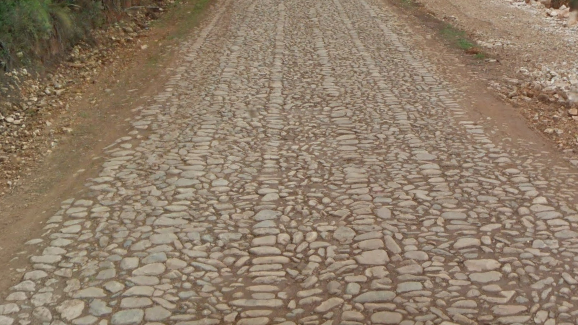
There are also a lot of cobblestone roads. These roads often have a specific pattern, with several neat lines of stones separating the more disorganised cobblestones in between.
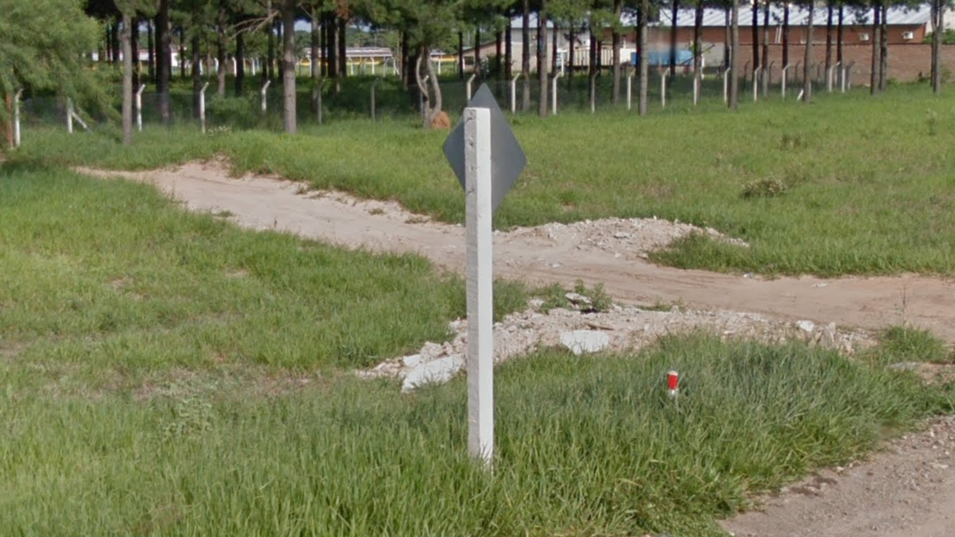
Bolivia typically uses bulky, white square signposts.
NOTE: Peru typically uses black and white striped “zebra” signposts.

Guardrails sometimes feature yellow and black markings. These markings always have the yellow stripes on the outside.
NOTE: Peru has similar markings. However, in Peru, the markings have the inverse colour scheme: the black stripes are always on the outside.

Two types of utility poles are common in Bolivia:
Round concrete poles, often with small pinholes near the top.
Wooden poles.
Poles in Bolivia are very inconsistent and should not be relied on too much. Poles can have a variety of pole tops. On rare occasions, you can find Argentina-style concrete poles.

Many wooden utility poles, particularly in the eastern parts of Bolivia’s Street View coverage, are noticeably curvy and look like they are made from locally sourced tree trunks.
NOTE: While you may see slightly bent poles in other places, extremely curvy poles are a very good clue for Bolivia.

Kilometre markers are black and white. The top part is black and features the abbreviation ‘Km’, while the bottom part is white and shows the distance. These markers do not have road numbers.
NOTE: They can look somewhat similar to Argentinian road markers, especially from a distance. The main difference is that the markers in Argentina feature a road number.

Many Bolivians wear traditional clothing, especially women. Folk dress for women typically consists of bowler hats, colourful shawls, and big pleated skirts (pollera).
NOTE: Similar folk dress can sometimes be found in parts of Peru, especially those close to Bolivia.

Bolivia’s ruling political party is called Movimiento al Socialismo (MAS). Political graffiti often features the words MAS and Evo, short for Evo Morales, who was president of Bolivia at the time the country was covered by Street View.
Additionally, many random objects are painted in the party’s colours: black, white, and a large blue field. This distinctive colour scheme is a good clue for Bolivia.

Bolivia has a second official flag, called the Wiphala. It is a square patchwork of seven diagonally arranged colours. It is sometimes seen on government buildings and project signs.

In urban areas, you will often see ads for the telecom company Tigo, with its distinct blue logo. Crucially, this company does not operate in Peru, meaning it can help you solve urban 50-50s.
NOTE: This company does operate in several other Latin American countries, so only use this tip to differentiate between Peru and Bolivia.

If all else fails, and you have a tough 50-50, it can help to look at the colour of the rocks and soil, which often have a distinct reddish tint in Bolivia, more so than the other Andean countries.
This information should be used with a fair amount of caution, as there are many variables. Only use it when you have no other clues available.

Coverage in Bolivia is very limited, both in geographic scope and the density of roads covered.
Only the central and central-western parts of the country have coverage. Most coverage is found in and around the six main cities of La Paz or El Alto, Cochabamba, Oruro, Sucre, Potosi, and Santa Cruz.
These aforementioned six cities have in-depth side-street coverage. Outside these cities, coverage is mostly limited to main roads. Beware that “main road” is a relative concept in Bolivia: many of these, even some that are marked yellow on the map, have large unpaved sections.

The Altiplano (“high plain”) is an immense highland plateau that dominates most of western Bolivia. It is covered in grasslands that range from green to arid. Some parts are suitable for agriculture, whereas other parts are extremely dry. Grass growing in tufts is common (sometimes referred to as “Bolivian hedgehogs” in the community).
NOTE: While it is generally fairly flat, you will often see hills and mountains around you. However, as a general rule, the road itself will be mostly flat.

The grasslands of the Altiplano tend to look more lush in the more northern half: the area close to El Alto and La Paz.
NOTE: Due to seasonal coverage, there are some exceptions to this, but in general this is a good rule of thumb to distinguish between the different parts of the Altiplano.

Conversely, the Altiplano looks more arid in the more southern half: around Oruro, and the roads going southwest towards Chile.
NOTE: There is one major exception to this: one driving side of the divided part of Ruta 1 looks somewhat green all the way up to Oruro (due to this coverage being captured in a different season).

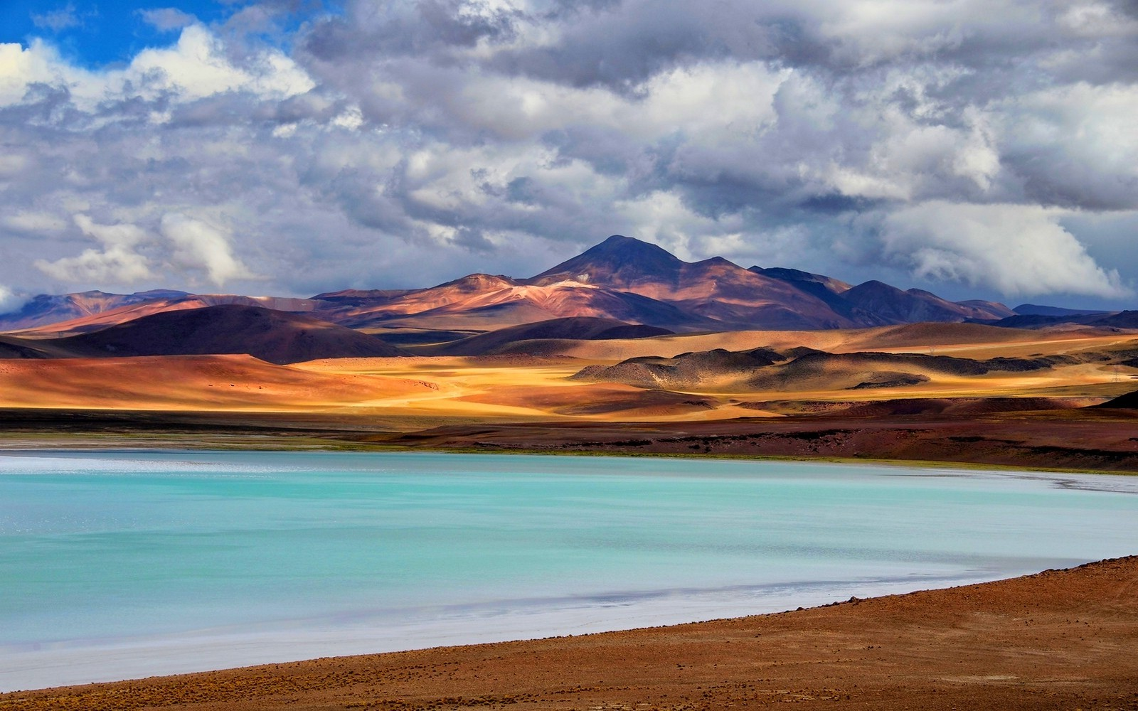
Lake Titicaca, on the border with Peru, is the most significant body of water in Bolivia. It is located entirely within the Altiplano. It can be seen from two roads:
The section of Ruta 1 between Desaguadero and Guaqui. Here, the lake will always be to your north.
The section of Ruta 2 between San Pablo de Tiquina and Batallas. Here, the lake will mostly be to your south or west.
The landscape around Titicaca is very green, compared to most of the western half of Bolivia.


The area east of the Andes is very green and tropical, with lots of agriculture – especially around Santa Cruz. This area is mostly very flat, though you will see large hills on some of the roads closer to the Andes. The soil tends to have a pink colour.

Within this tropical area, coverage on unpaved roads is only found around Santa Cruz. These roads again prominently have the pink soil that is very characteristic of the area east of Andes.
Only a couple of cities and towns in Bolivia have a lot of sidestreet coverage. Most of the cities can be easily and consistently distinguished from each other using a few basic tips.

La Paz and El Alto are twin cities that together form one big metropolitan area. However, despite being located right next to each other, they each have a very different look. See the tips below for more information.

La Paz is a very hilly city. Most of La Paz itself is situated in meandering valleys, surrounded by hills that often tend to be covered in green vegetation (as opposed to the more dry hillsides found in many other Bolivian urban areas).

Downtown La Paz is the only place in Bolivia where you will find very tall buildings (10+ storeys).

In many parts of La Paz, you can see these heavily eroded, pillar-like rock formations on the hillsides. They consist of a very recognizable yellow-beige sandstone.
Of the big cities with coverage in Bolivia, these rock formations are essentially unique to La Paz.

El Alto is situated on a very flat, highland plateau. It looks much drier and dustier than La Paz. The layout of its streets is also more regular and grid-like.
The city appears like an unending mess of semi-finished red brick buildings, even more so than other cities in Bolivia. Some neighbourhoods have a very rundown, desolate look.
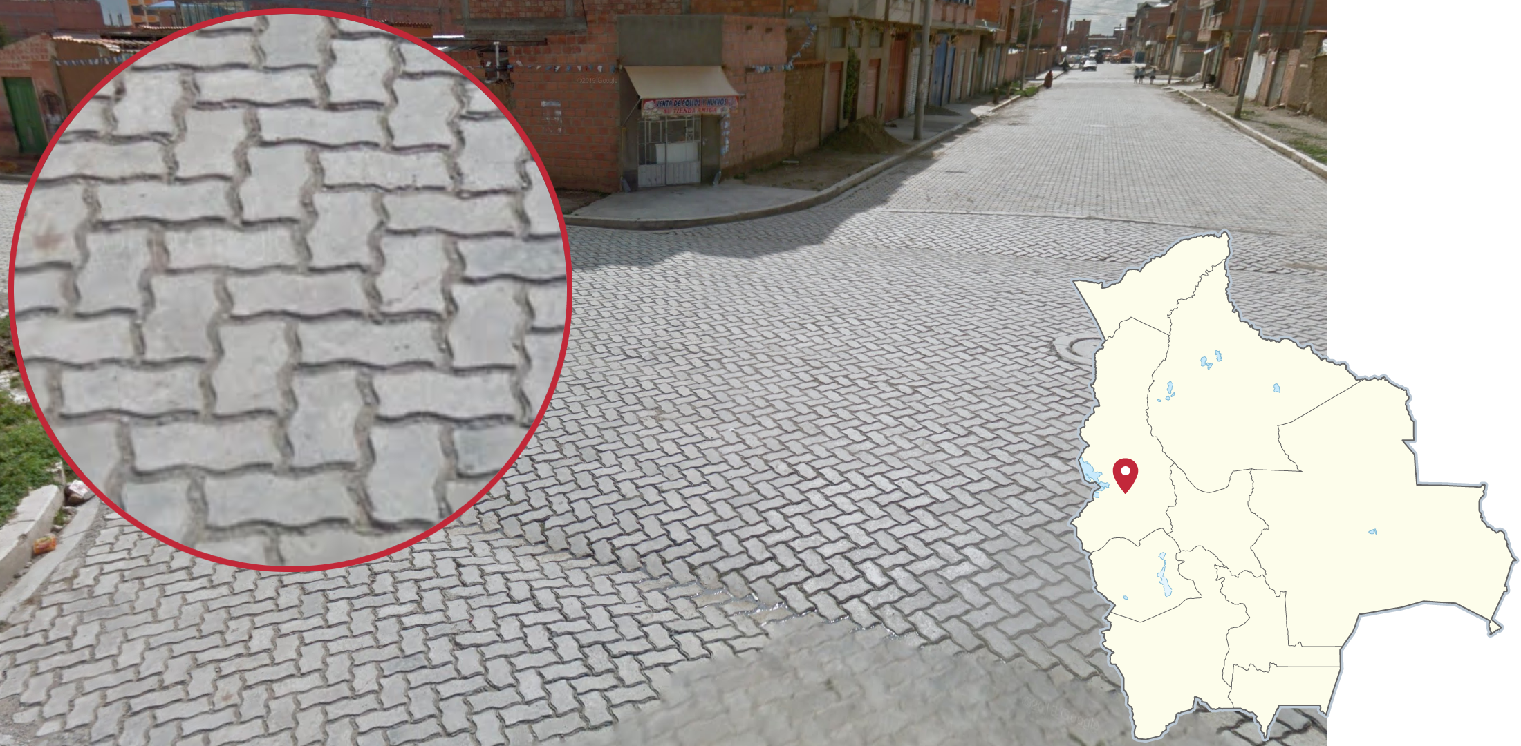
This type of pavement, consisting of rectangular grey bricks with slightly wavy edges, is very common in El Alto.

In El Alto, you can sometimes see a local type of architecture referred to as Neo-Andean. Buildings in this style are colourful, with elaborate, futuristic-looking façades. The style is really unique and is almost completely limited to El Alto.
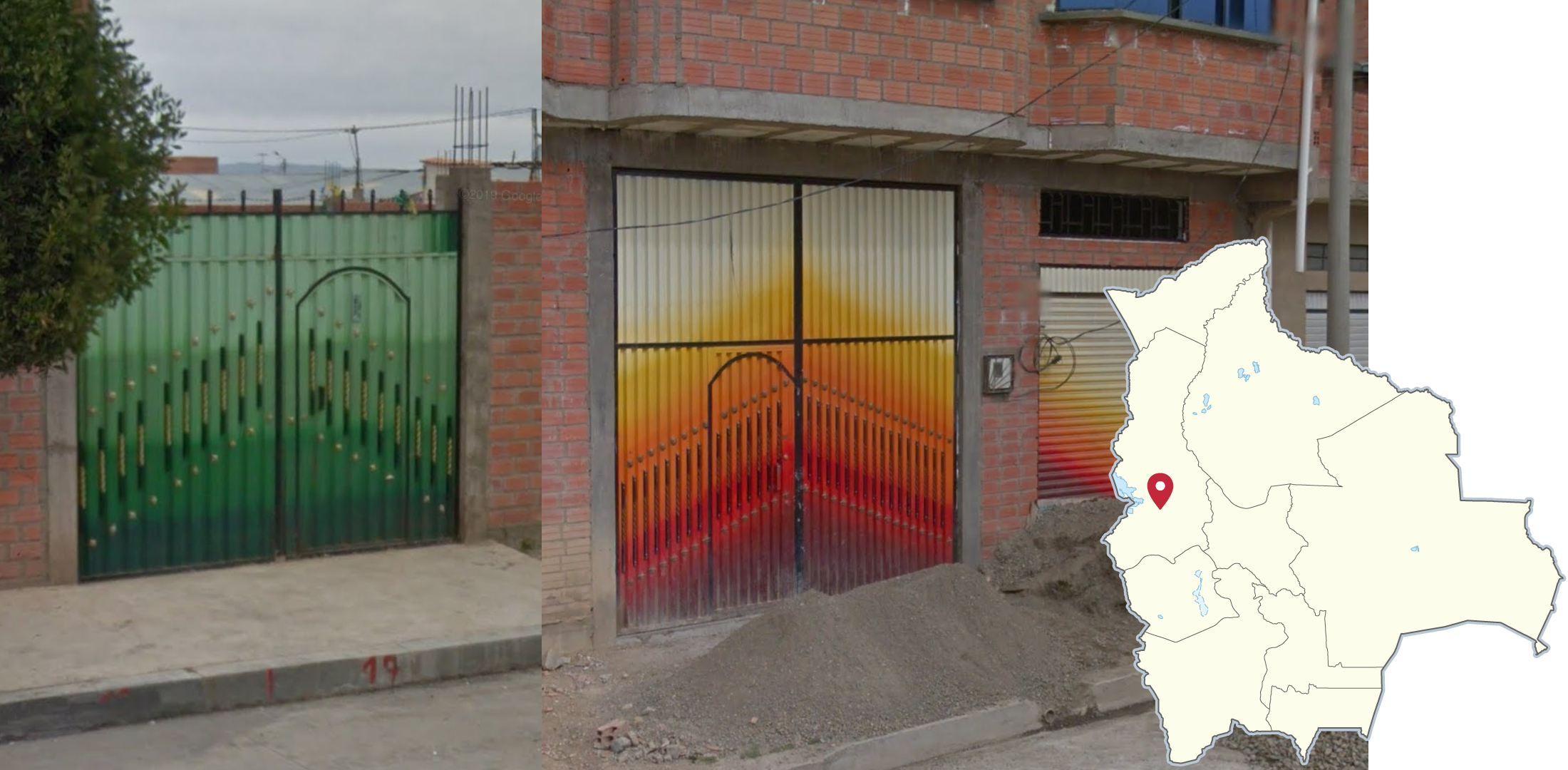
Gates and doors in El Alto are sometimes painted with a gradient pattern, usually dark green to light green, or red to yellow.

Cochabamba is situated in a large flat valley, where you will almost always see an imposing wall of mountains to your north. This is the single most useful and consistent way of distinguishing this city from other places in Bolivia.

Of all the major cities in Bolivia, Oruro is situated in by far the most dry landscape.
In Oruro, you will also usually be able to see a large dry hill to your west, in an otherwise mostly flat and very arid landscape.
NOTE: Potosí is also located in an arid landscape. However, it is considerably hillier.

Sucre is situated in a very hilly landscape, and as a result you can see many elevation changes in its streets. Uniquely, you can see these round, tree-covered hills in many parts of the city.

Sucre has a well-preserved historic city centre, with lots of old colonial buildings. The downtown area can be recognized by the white walls, orange tiled roofs, and generally more historic look than other places in Bolivia.

Potosí is also situated in a very hilly landscape, like Sucre. However, its landscape is much more arid, with little to no trees atop the hills.

In many parts of Potosí, you can see this colossal pyramid-shaped mountain called Cerro Rico. It is famous for having massive quantities of silver ore, and as a result its surface is stripped bare by extensive mining – which is distinctly visible in the street view coverage.

Santa Cruz is the only large Bolivian city located in a tropical (and flat) landscape.
Note that there are several smaller towns around Santa Cruz that look essentially identical. Some of these have extensive side-road coverage too.

Ruta 1 west of El Alto is a paved road that runs through green grasslands. The road itself is mostly flat, but you will usually see hills nearby. On the road, you will often see numbers marked in white paint.
Near the western end of the road, close to Desaguadero and the border with Peru, you will be able to see Lake Titicaca to your north.
NOTE: This road can look very similar to Ruta 2 northwest of El Alto. Road angles can help if you are not sure.

The section of Ruta 3 around Pongo, northeast of La Paz, can easily be recognised by the breathtaking views of enormous mountains, which are often surrounded by low-hanging clouds. The mountains are also recognizable by their dark grey rocks lightly covered in greenish grass.

The N Yungas Road (also popularly known as Death Road), is a bendy, small and unpaved road, high up in the mountains east of La Paz. The vegetation is very tropical. The coverage in the southern part of the road is very foggy. True to its unofficial name, this road looks like a very dangerous drive. You can sometimes see some daring cyclists.
NOTE: The northern half of this road looks less foggy and dangerous. However, it should still be recognizable, as it is the only dirt road meandering through jungle hills in Bolivia.

Ruta 1 and 4 between La Paz and Oruro is a large divided highway that runs through the Altiplano landscape of western Bolivia.
It is the only large, divided highway in the entire country. There are smaller, divided roads in and near some urban areas, but those should be easily distinguishable based on landscape and road size.
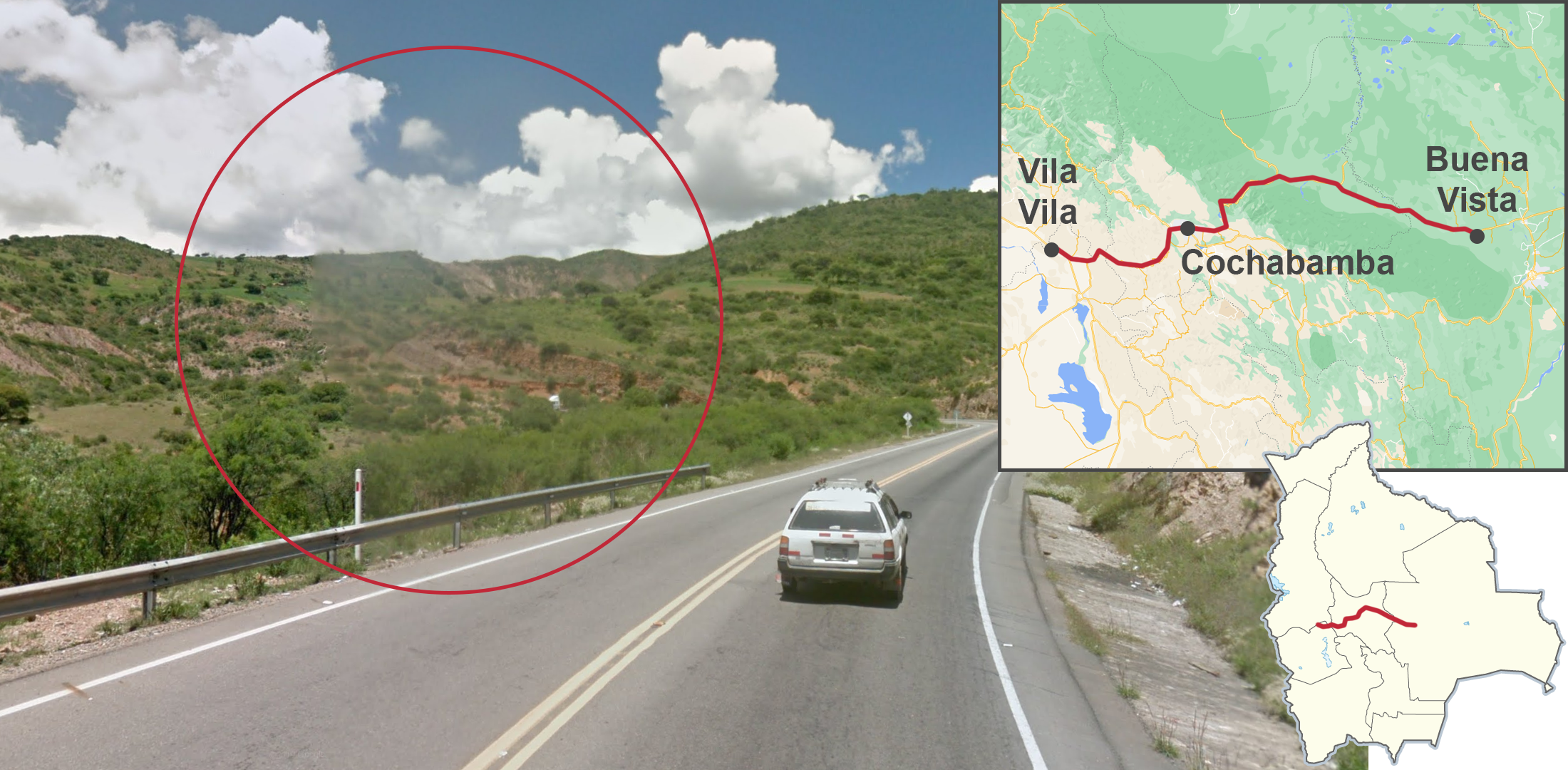
A long section of Ruta 4 has a distinctive square smudge on the front left of the camera. This coverage starts in the altiplano near Vila Vila, going east through Cochabamba, all the way to Buena Vista in the flat Amazonian part of Bolivia.

Around Morochata, northwest of Cochabamba on Ruta 25, there is a small isolated piece of coverage that looks extremely similar to Peru. It is a dirt road that meanders through a mountainous landscape. Knowing this road can be extremely helpful for country streak purposes.
The western part of this road is located in a green mountain landscape, with fields on the mountain slopes and lots of eucalyptus trees around.
Towards the east, it transitions into a more arid high altitude landscape that still looks very similar to Peru.

Ruta 1 between Machacamarca and Guindal runs through an arid landscape where you will often see patches of snow on the hilltops, and sometimes even next to the road. Weather conditions range from cloudy to fully overcast, lending this coverage a gloomy look.
The aforementioned road can be regionguessed even more precisely. See the next two tips.

The section north of Challapata runs in a general NNW direction, with straight roads in flat terrain, with hills on one or both sides. Weather conditions are a little bit better, with some of the sky visible, especially when looking south.

The section southeast of Challapata tends to be more curvy and hilly. The weather is much worse, with grey skies.

The section of Ruta 7 between Mairana and the outskirts of Santa Cruz has coverage with a camera bug that causes a visual glitch. It is a distinctive, neon-like discoloration, that (depending on the road angle) is usually more or less to your north.
NOTE: This glitch can also rarely be found in some limited areas in and around Santa Cruz. In these areas, the glitch is often not as severe.

The roads around the town of Mataral have recognizable coverage: a very green, hilly landscape, and sunny weather with only a couple of clouds. While the hills are very green, the vegetation is not very dense, and quite low.
This coverage is limited to Ruta 7 from Comarapa to Mairana, and Ruta 22 to Vallegrande. Other roads in Bolivia with similar vegetation tend to either have different weather (overcast) or terrain (more flat).

In the aforementioned Mataral area, you will often see large cacti hiding between the bushes, as well as trees with yellow flowers.

The eastern section of Ruta 4, east of Santa Cruz, runs in a general east-west direction, through a mostly flat, green landscape. In some places, you can see some low hills. This road has both asphalt and concrete pad sections.

The section of Ruta 5 around Chaco, just north of Sucre, has distinct sunset coverage. Most of this road has concrete pavement, and meanders through semi-arid hills.

The section of Ruta 4, southwest of Patacamaya, runs through a semi-arid grassland landscape. Many parts of that road between Patacamaya and Callapa have worn-down grainy asphalt.

On the southwesternmost section of Ruta 4, you can usually see the Nevado Sajama, an isolated snow-capped volcano that is very distinct and unlike any other mountain in Bolivia.
When you see Sajama, you will always be south of Callapa and the Desaguadero River. However, you will not always be able to see it on this section of the road, as it is often hidden by hills.
NOTE: The only other place where you can see Nevado Sajama is coverage in the National Park, which is recognizable by its unique Google car.

The section of Ruta 6 between Tarabuco and Zudáñez is paved with extremely light-coloured concrete, bordering on white. This pavement is very recognizable and unique to this road.

Between the villages of Villa Catalina and Coipasa, there is an isolated stretch of coverage where the Google car drove through extremely arid desert terrain. This small road is located close to the southwestern end of Ruta 12, near the Chilean border. It can be hard to spot on the map, because it blends in with the salt flat.
Closer to Villa Catalina, the car drove over the salt flat. Closer to Coipasa, the car drove on an unpaved dirt road, where you can see cone-shaped volcanic hills. In both parts, there is virtually no vegetation.

Sajama National Park was covered by this unique Google car: it has a black roof rack with a series of metal bars.
The coverage is on an unpaved road surrounded by fluffy bushes. The Nevado Sajama volcano is always visible. The car briefly drove through the small village of Tomarapi, which can be recognized by its traditional buildings with adobe walls and thatched roofs.
GeoGuessr’s own official maps are not very good, for a variety of reasons. Plonk It recommends the following maps instead: