
Albania


Albanian licence plates either have blue strips on both sides or a single red strip on the left side.
NOTE: Albania is the only European country with red on the left side of the licence plate. Furthermore, Italian licence plates also have blue strips on both sides, however Italian front plates are distinctly shorter.

‘Rifts’ can commonly be seen in Albanian coverage, due to poor stitching.
NOTE: Rifts are also equally common in Montenegro, and can rarely be seen in various other countries.

Albanian bollards have a black top with a red and grey reflector. The bottom is painted white.
NOTE: Italy uses the same kind of bollards.

These pole tops, with an upside down triangle shape, are a good clue for Albania.
NOTE: Serbia, Czechia, Slovakia and Romania use similar pole tops.

Other, more simple Albanian pole tops will often have horizontal bars.
NOTE: If you are not sure between Montenegro or Albania and see these poles, guess Albania.
Albanian chevrons are white on black.
NOTE: Within southern Europe this chevron is also used by Italy, Greece, and Spain.
Montenegro uses two chevrons, both of which are different from the Albanian chevron: black on white and red on yellow.

The backs of road signs are often painted black.
NOTE: This is also common in Italy and Romania.
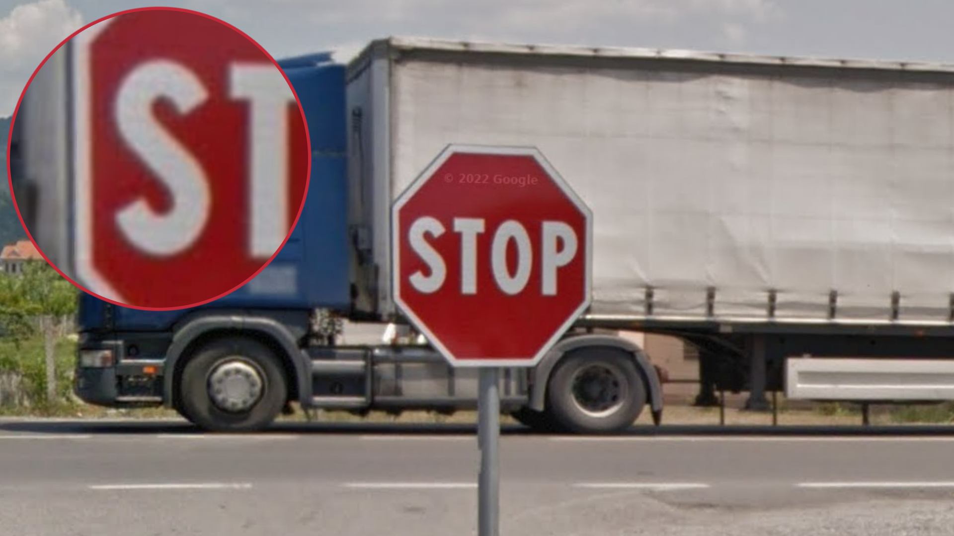
The “S” on Albanian stop signs feature a distinct shape; the ends of the S are quite short and have the same angle as the middle, rather than being vertical. This is also sometimes seen on directional signs.
NOTE: Italian stops signs and directional signs have the same feature.

The numbers on speed signs are written in a bold font.
NOTE: The font is much thinner on speed signs in Montenegro.

These flat and wide guardrail endings that bend away from the road can often be found in Albania.
NOTE: The same endings are found in Italy.

Albanian is not very closely related to any other European languages, and therefore has a fairly distinct look.
Words often contain the letter Ë, ë, and sometimes Ç ç.

The Albanian word for street is rruga.

Albania is generally a mountainous country, with a Mediterranean climate and vegetation. In between the hills and mountains, you can sometimes find more flat, agricultural valleys. The mountains are usually quite green, sometimes with patches of exposed rock visible.

Albania has a lot of exposed red soil next to roads.
NOTE: This is less common in Montenegro. Greece on the other hand also has a fair amount of similar-looking red soil, especially closer to the Albanian border.

You will see a lot of cylinder-shaped water tanks on the roofs of buildings.
NOTE: This is less common in Montenegro.
Some parts of Turkey also have a lot of similar-looking water tanks.

Albania has a lot of Italian-style buildings: pastel colours, orange tiled roofs, and blocky shapes with lots of balconies.

Mercedes is the most popular car brand in Albania, by quite a margin. The specific style of sedan pictured here is particularly common.

Coverage in Albania is limited. Generally only the larger towns have extensive side-road coverage.
Note that while the coverage is limited, a lot of it still appears to be very rural. It is not just on big main roads or urban areas.
You can click on the image to enlarge it, or use this site to study the official coverage in detail.

There are two types of car and camera meta in Albania:
Coverage where the Google car has a long antenna and you can see rifts in the sky.
Coverage where the Google car has a short antenna and there are no rifts visible.
You can click on the image to enlarge it. You can also use this Maps layer to look at the coverage in more detail (credits to icraig1205).

Albania is generally a very mountainous country. This map shows the elevation and relief.
Low-lying areas are mostly concentrated in the west, around Shkodër, Tirana and Vlorë. This part of the country is characterised by agricultural flatlands and low, undulating hills. Note that the highland plateau around Korçë in the southeast is also very flat.
The highest mountains can be found in the far north and the far south. In places, these mountains can have an almost alpine look.
You can click on the image to enlarge it.

The road leading into Theth National Park can typically be recognised by the tall, jagged mountains, often with bare mountainsides.
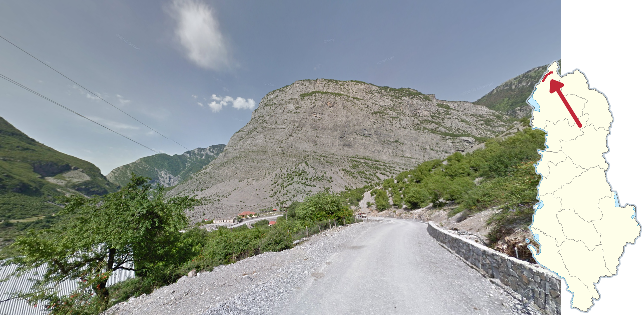
The road by the eastern part of the Montenegrin border goes in a valley with tall, fully exposed cliff sides along the road.
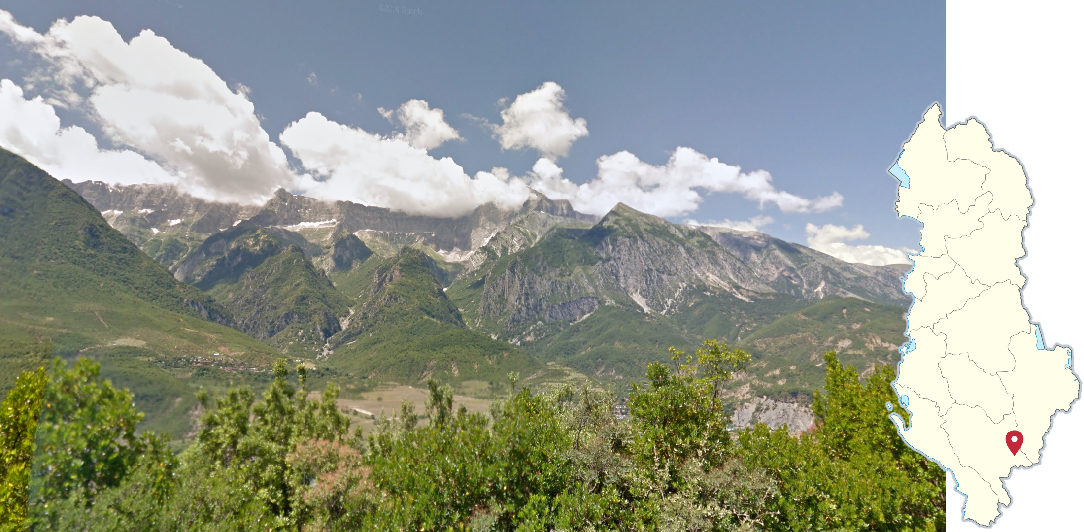
Maja e Papingut is a massive mountain in the south of Albania, with an almost completely vertical cliffside near the top. It can be seen from several nearby roads.
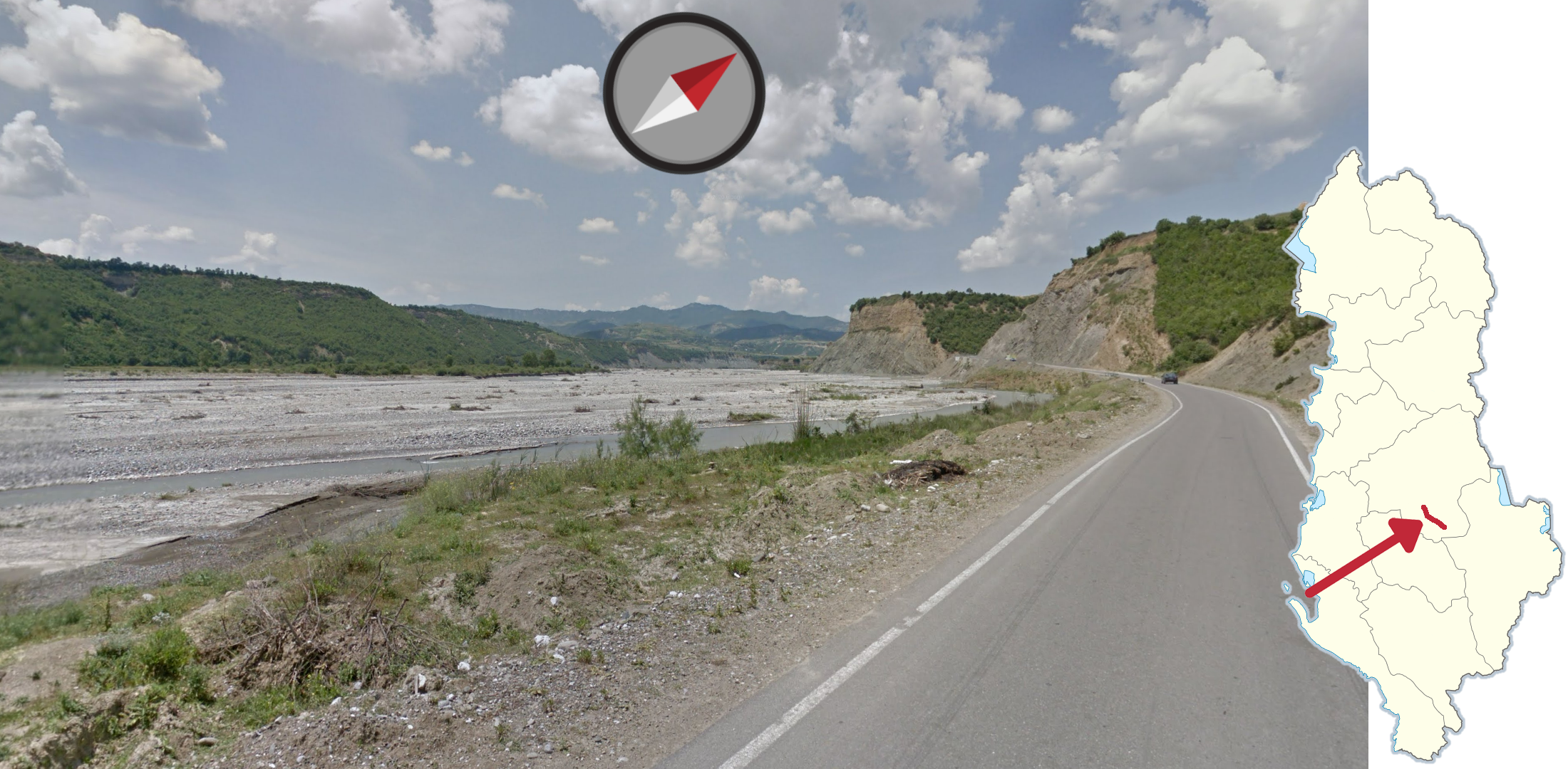
A wide, almost dried out river valley going southeast to northwest, can be seen along the SH71 between Pishaj and Kokel.
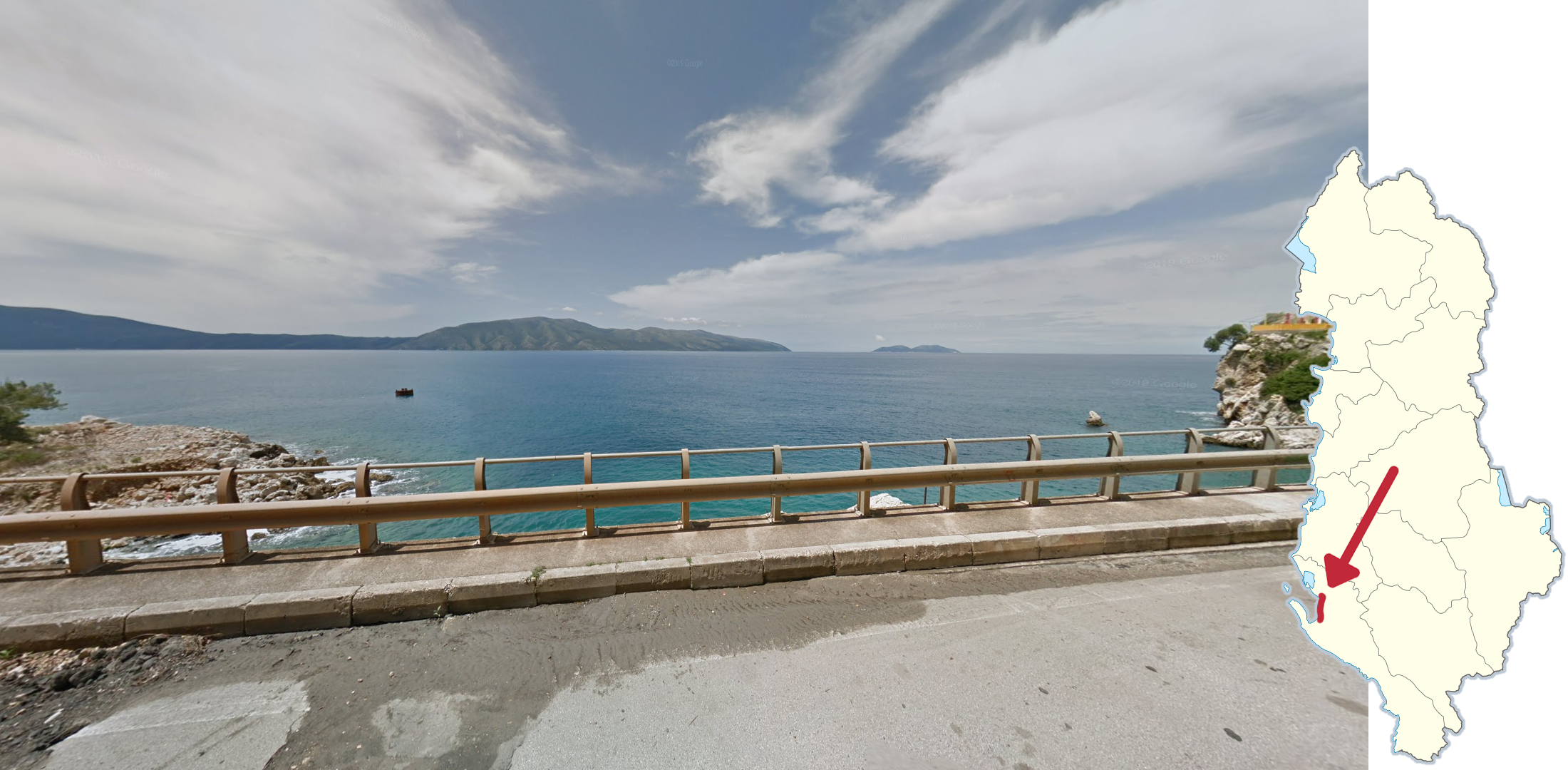
The large Bay of Vlorë can be seen on many parts of the SH4 between Vlorë and Orikum. It can be recognized by the large Karaburun peninsula jutting out into the ocean from the south, and the small Sazan island just to its north.

A couple of small roads northwest of Vlorë can be recognised by the very coastal-looking Aleppo pine forest.

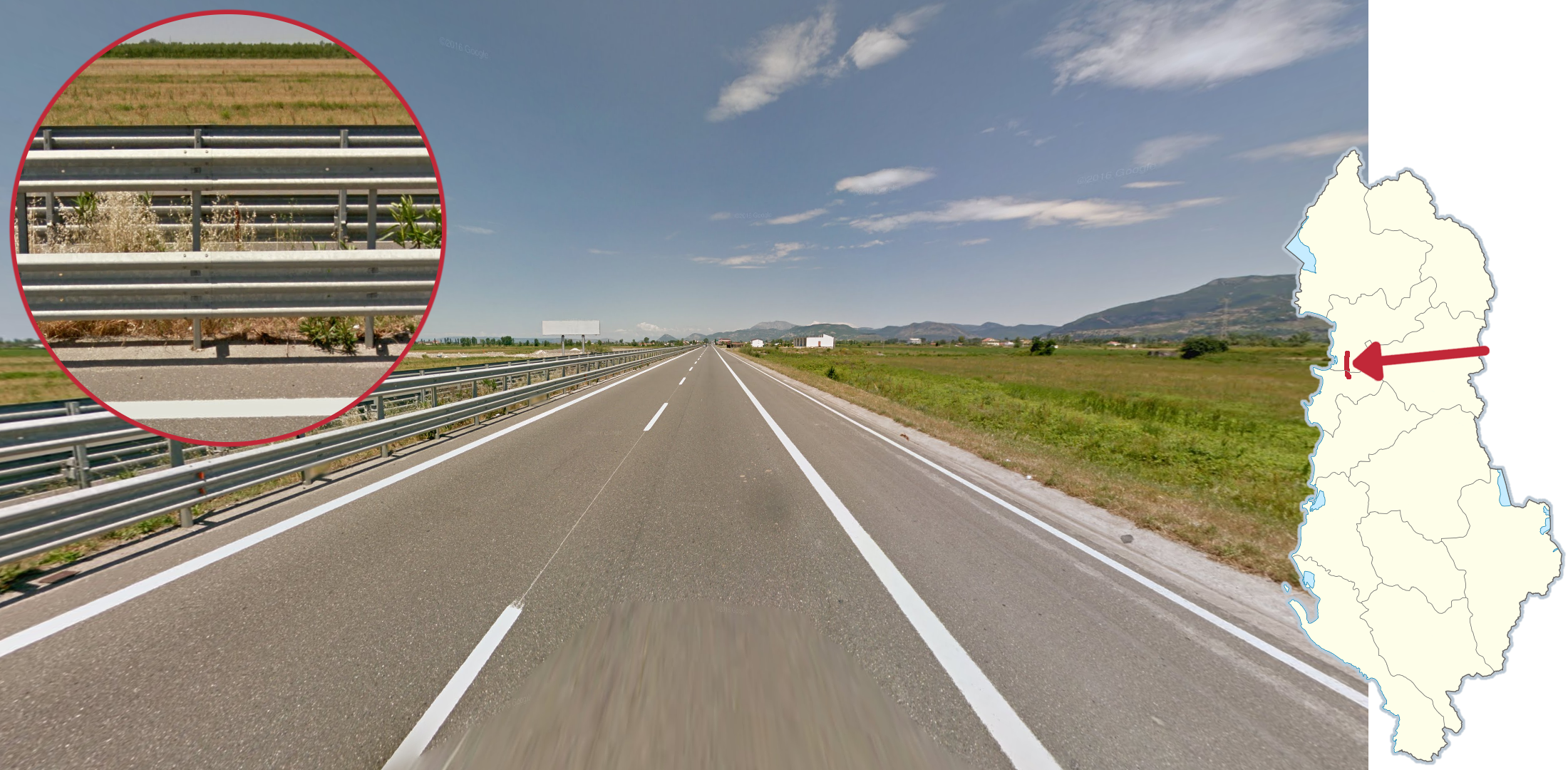
On the SH4 between Levan and Tepelenë and right by the Greek border, you may see double outer road lines with a wide gap between them.

On this section of the E86 near the Greek border, you will sometimes see these unique bollards. They have a round shape and a simple red reflector. They look superficially similar to the flatter Turkish bollard.
Yellow centre lines

There are three sections of road in Albania with yellow centre lines. The first is on the E86 near lake Ohrid with the lake in the east, making it easily recognisable.

The second is the SH97 which goes through a fairly hilly landscape. It also goes through some smaller valleys.

The final road with a yellow centre line is the SH1 north of Tirana. It goes through a wide valley with fairly tall mountains on either side.
Divided highways
Albania only has a few divided highways covered on Street View. All of these and how to differentiate them will be covered in the tips below.
The most easily recognisable divided highway is the A1 between Fushë Milot and Thumanë, which is the only one with a triple guardrail.

The sections of the SH2 between Durrës and Tirana and of the SH4 between Lushnjë and Rrogozhinë are both divided by simple concrete blocks.

In Tirana, Durrës and on the A3 and SH3 south of Tirana you can find highways which are divided by concrete blocks, with grass and greenery in between.

Most of the SH4 between Durrës and Fier is divided by a basic double guardrail. The road does not go through any mountains.

The E851 is the only divided road with a basic double guardrail that goes directly through mountains.
NOTE: A section of the A3 goes through the mountains but is either divided by a double guardrail with a fence above, or with concrete blocks.
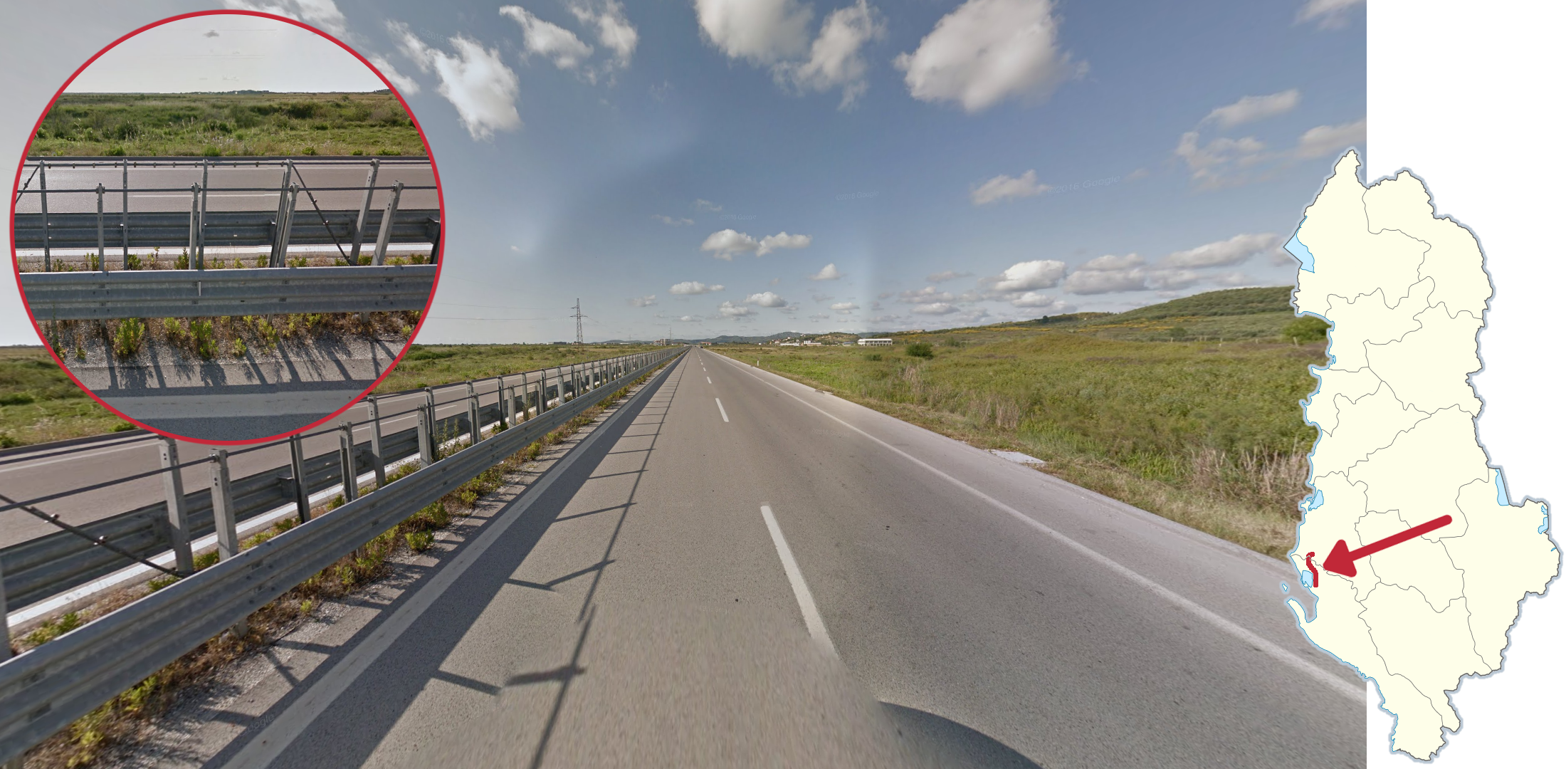
The A2 north of Vlorë can be recognised by the fairly flat surroundings combined with the double guardrail with an extra tall fence dividing the highway.
Cities

The city of Lezhë can often be recognised by the old castle at the top of a tall hill.

Gjirokaster is a city situated on the western hillside of a wide valley.
GeoGuessr’s own official Albania map is not very good, for a variety of reasons. Plonk It recommends the following maps instead:
A Balanced Albania (map link) - 23k arbitrarily generated locations. Balanced, but not pinpointable.
IntersectionGuessr - Albania (map link) - Pinpointable, but not very balanced. A lot of the locations will be in or near the big urban areas. It does have the advantage of being a good map for moving 25k games however.
In addition, here are some resources to help you practise Albania:
Plonk It Albania (map link) - This map contains locations for practising each meta in the Plonk It Albania guide from step 2 to 3.