
South Africa


South Africa drives on the left.
NOTE: A handful of other countries also drive on the left. See this infographic for more information.

On most roads, South Africa utilizes single yellow outer lines and white centre lines.
NOTE: The other southern African countries of Botswana, Eswatini, and Lesotho also use single yellow outer lines.
Australia practically never uses yellow outer lines.

South Africa occasionally features unique white triple centre lines with 2 solid lines on the outside and a dashed line on the inside.
You may also sometimes encounter another unique triple centre line, consisting of two white lines with one yellow line in the middle. These centre lines are usually found on larger main roads.
NOTE: The only other countries where you will find road lines like these are the other southern African countries of Botswana, Eswatini, and Lesotho.

Generation 2 coverage is quite common in the country.
It can be recognized by the large circular car blur and the halo-like colour distortion in the sky.
NOTE: On the continent of Africa, Generation 2 is only found in South Africa.

South Africa has 11 official languages: English, Afrikaans, and various Bantu languages. English is the lingua franca and therefore appears most often on signage.
Afrikaans is a Germanic language that is closely related to Dutch. Common Afrikaans place name suffixes are -fontein, -kraal, -kop, -dorp, -nek, and -berg or -burg. While Afrikaans is most commonly spoken in the western half of the country, you will find Afrikaans place names all over South Africa, meaning that it is not useful for region-guessing.
NOTE: Afrikaans is rare to non-existent in Eswatini and Lesotho. It is also abundantly rare in Botswana, but has some limited presence in the form of place names.

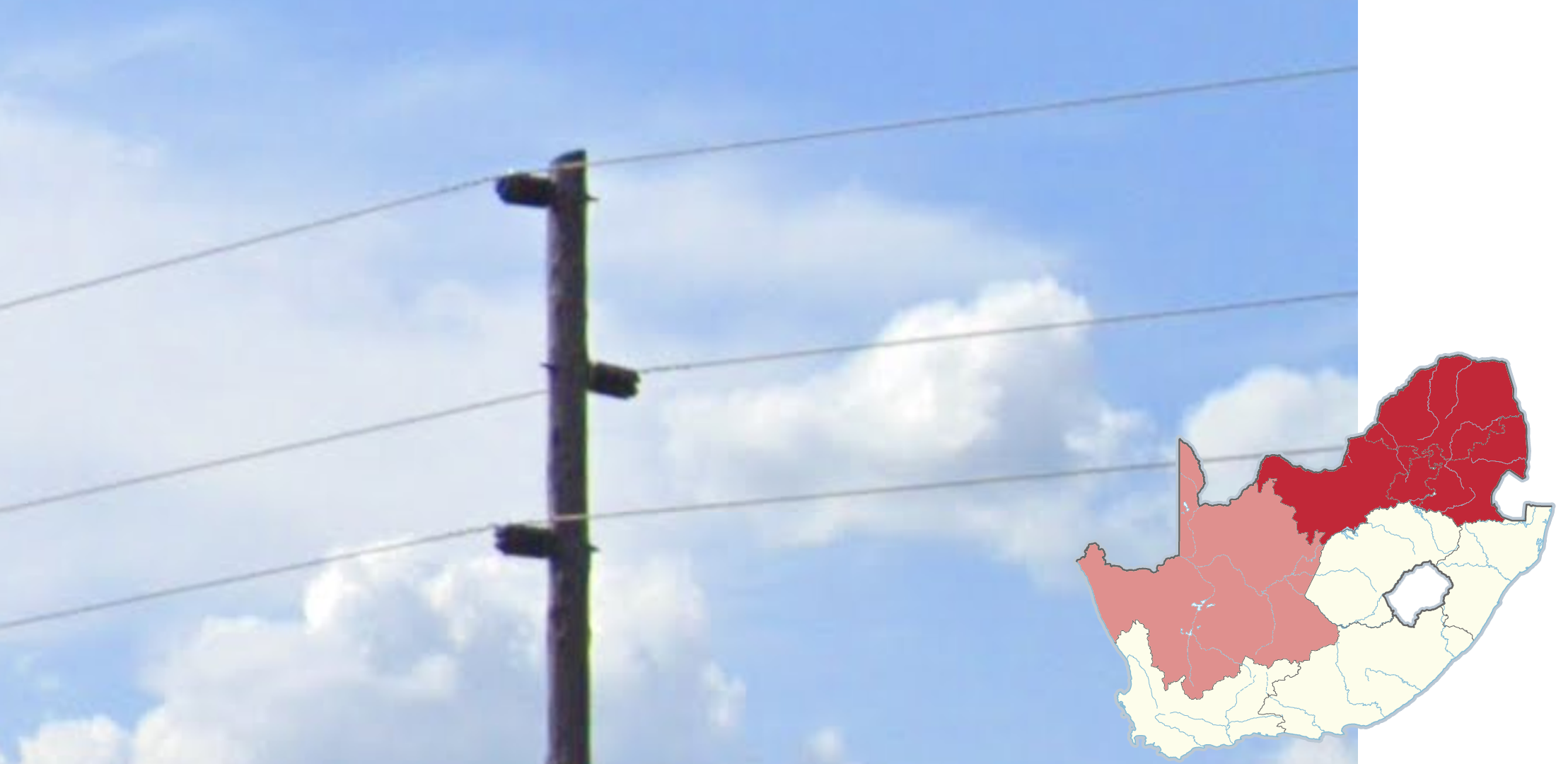
The most common type of pole in South Africa features 1 to 5 horizontal bars with thin white insulators that resemble rows of birds, which is why they are referred to as “bird poles” in the community.
NOTE: South Africa has a wide variety of other poles and pole tops. Some of these are (mostly) limited to a certain region; you can learn more about them in the region guessing section.

South Africa uses green directional signs with the road number in yellow.
NOTE: Green directional signs with yellow road numbers are also used in Lesotho, Eswatini and Botswana. Here, the format of road numbers is useful:
N and R-roads are exclusive to South Africa.
A and B-roads are exclusive to Botswana and Lesotho.
MR-roads are exclusive to Eswatini.

South Africa utilizes triangular warning signs with a red border and a white background.
NOTE: Botswana, Eswatini, and Lesotho use similar warning signs.
Australia and New Zealand use yellow diamond-shaped warning signs.
South Africa uses white-and-red chevrons. You can find a similar chevron pattern below directional signs.
In addition, unique-looking small, thin chevrons with one arrow are common next to roads.
NOTE: The thin chevrons can also be found in the other southern African countries of Botswana, Eswatini, and Lesotho.

Suburban houses in and around large cities will often be surrounded by high walls, fences, and gates to deter criminals.

All Generation 4 coverage in South Africa was taken by a blue Street View car with a short antenna.
NOTE: The antenna is sometimes hidden by the blur.

South Africa also has Generation 4 “smallcam” coverage, which is mounted lower than regular Generation 4 and has a relatively big circular blur with a small protrusion at the front. The blur can also be fully transparent, but with a short antenna on the back.

Each province features a different licence plate design, which can be somewhat visible through the blur. Most notably Free State or KwaZulu-Natal, which have a slight green tint and blue tint respectively.
You can click on the image to enlarge it.

A map of major highways in South Africa. On road signs, the letter ‘N’ should appear in front of the highway number. On Google Maps, however, the letter ‘N’ will not be present. Instead, a blue pentagon with the number will be displayed.
You can click on the image to enlarge it.

Most of the R-roads with three-digit road numbers are geographically grouped. However, many roads go through multiple provinces and some, especially the 100s, are spread throughout the whole country. The map shows roughly where you can find each set of R-roads.
You can click on the image to enlarge it.

Telephone numbers are 10 digits long. The first three digits of landline numbers are the area code. The first digit is always a zero; the second and third digits give you the area. The area codes are geographically grouped, so even learning just the first digit is useful.
NOTE: Mobile phone numbers start with 06–08. These numbers are not specific to an area.
You can click on the image to enlarge it.
Image provided by dbldk.
Infrastructure

Poles with 3 bars forming the letter ‘A’, with the bottom insulators being attached at the edges of a horizontal bar, can be found almost exclusively in Western Cape, and rarely in bordering provinces.

A similar poletop can be found in Eastern Cape, however the A-shape is noticeably wider and the bottom insulators are attached directly to the ‘A’ rather than a horizontal bar.

Trident pole tops are almost unique to KwaZulu-Natal.
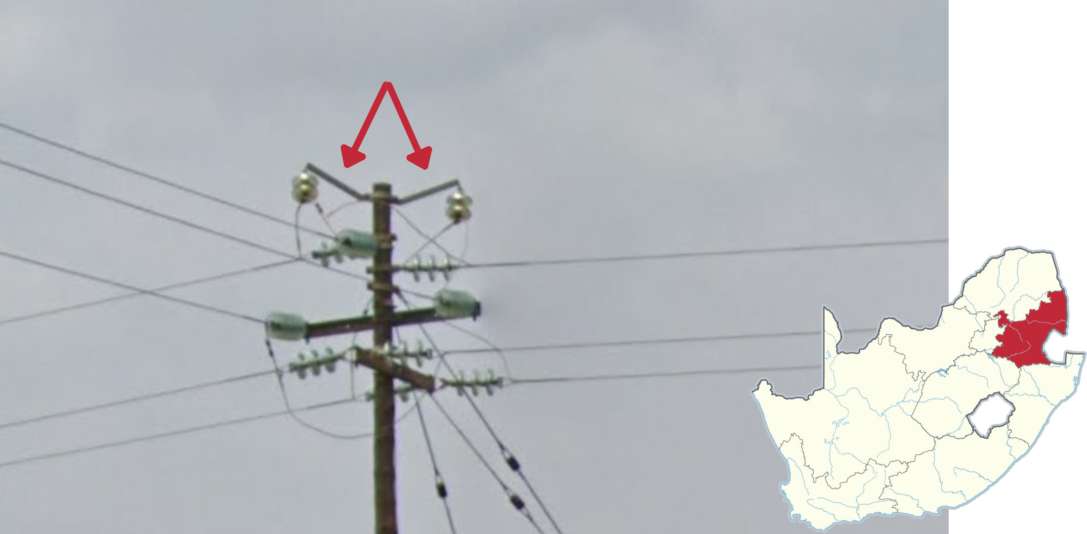
Poles with 3 alternating insulators sticking out horizontally at the top are mostly seen in the four northern provinces of Limpopo, Gauteng, North West and Mpumalanga. They can also sometimes be found in Northern Cape. In the rest of the country, these pole tops are exceedingly rare.

Poles with 2 diagonal bars forming a ‘<’ shape can be found mostly in the northeastern provinces, most commonly in Limpopo and North West.
Poles with 1 or 2 metal arms holding up insulators are most commonly seen in Mpumalanga.

Square, red stickers on the back of regular signs are often found in Eastern cape and close to Eastern cape in Northern Cape and Free State. You may see them in the North West province as well, but to a lesser extent.
NOTE: Red stickers on the back of chevrons can be seen in almost every province.
White stickers on the back of chevrons are often seen in the Cape provinces.

You can find this grainy, almost Texas-like pavement with a hint of pink in Limpopo.

Big bird nests on top of poles are commonly seen in the northern part of the Northern Cape Province.

Power plants are often seen in between the town of Secunda and eMalahleni in Mpumalanga.
Landscape

The northeast of the country can look very dry and somewhat barren, with a lot of orange or red soil. You will often see hills or mountains covered in shrubs.
NOTE: Depending on the season, the coverage can change drastically from dry to very green.

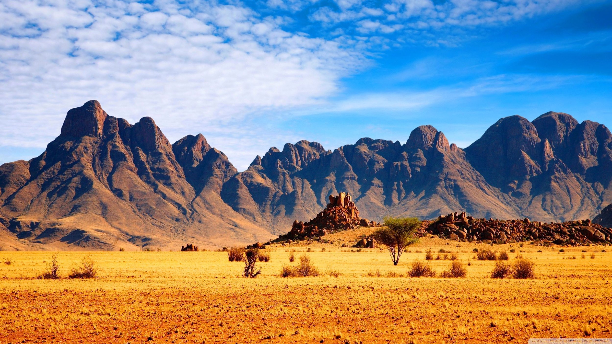
Unique rocky, treeless mountains can be seen in Western Cape, with most of the mountains having tall, steep sides and sharp peaks.
NOTE: Similar mountains can be seen in and around Lesotho.

Vineyards are almost exclusively found in Western Cape, mostly in valleys near the coast. You can also commonly find them near Upington, in Northern Cape.

A dry landscape with red soil is typically found in the Northern Cape.
NOTE: This map is a useful guide in guessing based on the climate of South Africa.

Sugarcane plantations are most commonly seen in KwaZulu-Natal, mostly along the coast. However, they can also be seen in Mpumalanga on the Mozambique border. For an overview, see this map.

Uniquely tall Cook pine trees are found mostly between the cities of East London and Durban along the southeastern coast.
NOTE: These are planted and not native, so they can be found anywhere along the coast.

Tree plantations that consist mostly of pine are common to the west of Eswatini, and some to the south in KwaZulu-Natal.
NOTE: Pine tree plantations are typically seen within the country of Eswatini itself.

Grassy rolling hills are generally located in the coastal area of Western Cape between Cape Town and George, and just north of Cape Town. Tall ridges are usually visible to the north or east.

The landscape near the Mozambique border in the highlighted area is noticeably flat, with green subtropical vegetation.
Miscellaneous

A camouflage car with black side mirrors and roof racks can be seen in Kruger National Park, on the Mozambique border.
NOTE: The Park now also has generation 4 coverage.

The landscape around Kruger National Park is generally flat, with a savannah climate and dry vegetation. You will not see any agriculture and the vegetation is mostly made up of grasses, with small trees dotting the landscape. Red soil can also be seen below the grass.
In addition, this distinctive directional waystone is commonly found at many junctions.
NOTE: Within the coverage of the park, you will mostly find unpaved gravel roads or small and paved roads without road lines.

Metropolitan Routes are major roads around cities. They are designated with the letter M.
These distinct and unique M route signs are commonly found in Port Elizabeth (Gqeberha) and Durban, respectively.

Traffic lights and pedestrian crossing poles in Johannesburg are encircled by three strips of reflective tape.

While this lamp and arm can be found uncommonly across the country, Durban uniquely has this bump on the top. You may, however, still see the standard lamp and arm.
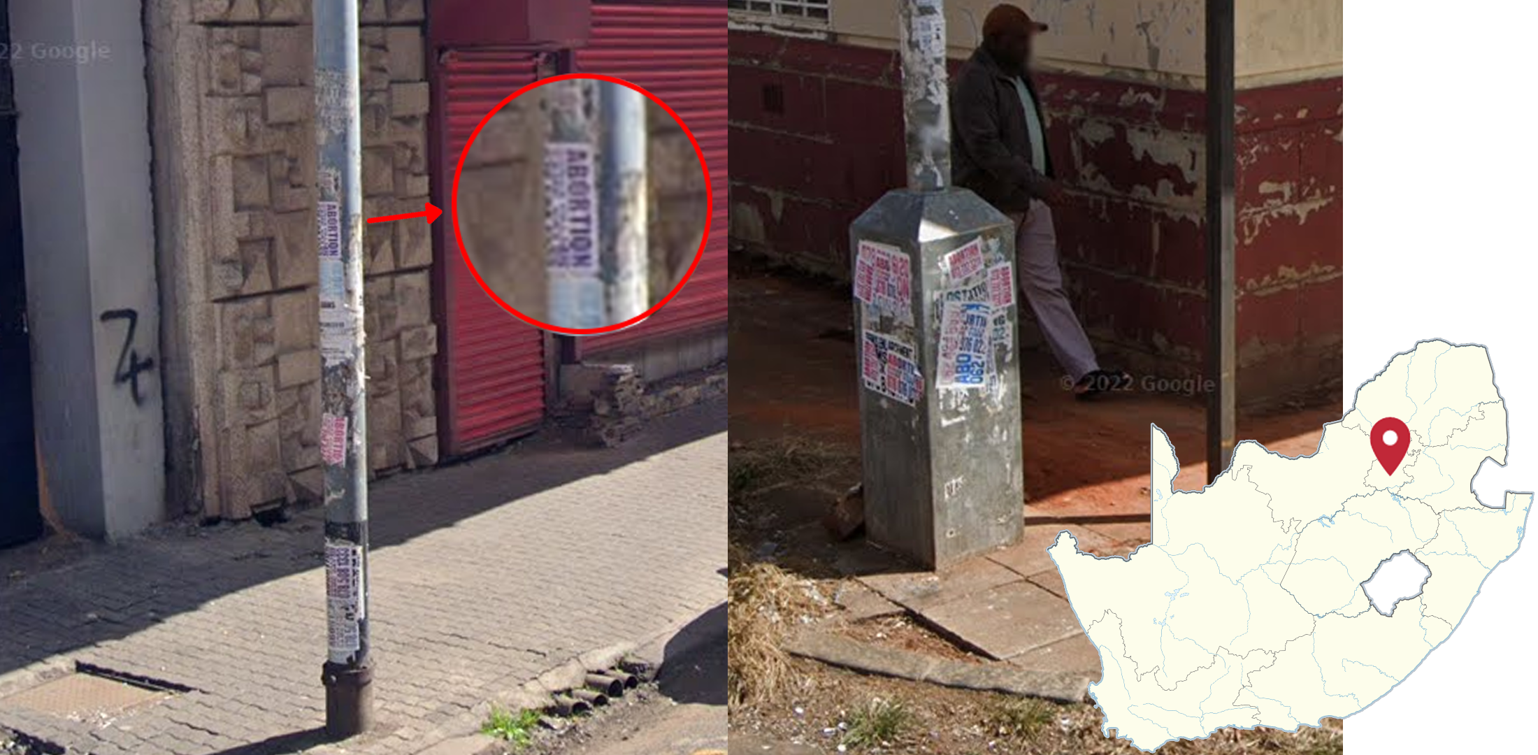
Poles or any public infrastructure will often be plastered with dodgy adverts for abortion services or penis enlargement pills in and around Gauteng, in particular in Johannesburg and Emalahleni.

The section of the R360 north of Bokspits, next to the Botswana border, has asphalt with a recognizable reddish tint. The landscape is arid and features dry greyish trees, shrubs and long golden grass. The road runs in a general north to south direction.
NOTE: Asphalt with a reddish tint can be found on other roads and the southern part of the R360. However, the landscape north of Bokspits looks predominantly like this.

The distinct Table Mountain, located west of Cape Town, can be recognized by its prominent three-kilometre plateau. It is flanked by Devil’s Peak, which is more pyramidal.

Mountains in the Witfontein Nature Reserve, likely George’s Peak, will be visible north from the city of George.