

Oman
Step 1 – Identifying Oman


Most of Oman features a desert landscape with little vegetation. While the middle and southern half is mostly flat, the north coast features dry mountains similar to those found in the UAE. The southern coast also has mountains, though less dry.

Licence plates on private vehicles are generally yellow, while commercial vehicles have red plates.

All the coverage in Oman was taken with a white pickup truck, meaning you will either see most of the car or a large front blur.

The official language in Oman is Arabic.
NOTE: Due to high tourism, signs in Oman often have English writing alongside Arabic. The same also applies to the UAE.

Roads in Oman use yellow outer and white middle lines.
NOTE: This is also common in the UAE, Israel, Jordan, as well as occasionally found in Qatar.

Black-and-yellow curbs are common in Oman.
NOTE: The UAE also commonly uses similar curbs.

Buildings in Oman are typically made of light-coloured stone. The houses are ‘blocky’ but still quite ornate, and they are usually surrounded by a matching fence, which often has an even more ornate gate.
NOTE: Buildings in the UAE are often very similar.

Directional signs are blue with white text and are usually in Arabic and English.
NOTE: The UAE and Qatar use similar signs.

Many signposts in Oman have black-and-white stripes.
NOTE: Within the Middle East, striped signposts are only found in Oman and the UAE.

Oman typically uses wooden poles, which have pole tops consisting of three varying designs. The first two have 3 insulators, symmetrically attached to a horizontal metal bar. The design with the metal triangle above the wooden pole is unique to Oman. The third design has the insulators attached to the side. Poles in general are more common in Oman than in the UAE or Qatar.

Oman uses black-and-yellow chevrons that have an unusually large number of arrows.

High voltage pylons painted with a red and white pattern are common in Oman.
NOTE: Within the Middle East, red and white painted pylons can also less commonly be found in Qatar.

The vast majority of garbage bins in Oman are either black and made of plastic or metallic and grey, with a three-leaf logo and the text ‘be’ah’ below it.
NOTE: Garbage bins in the UAE will occasionally have the text “bee’ah”, with two E’s. The bins are often more colourful too.

Oman uses white taxis, which have orange-coloured panels on each side.

Northern Oman features a dry mountainous landscape similar to eastern UAE. The south coast of Oman also rarely features some similar mountains.

Close to the southern coast, especially around Salalah, you will find a rolling hills landscape. The area commonly features rocky ground, bushes and small trees as well as some fairly green valleys.

The mountains north of Nizwa have an amount of green bushes that are unusually large for the north. The mountains are very rocky and jagged, which differentiates them from the more rolling mountains in the south.

Sandy desert with light coloured green and yellow shrubs can be found in northeastern Oman, mainly south and west of Bidiyah.

South of Bidiyah you can find a couple of dirt roads going through a slightly rolling landscape consisting of orange-pink sand and small yellow-ish shrubs. The roads mainly go between long and low sand dunes with a general south-south-west direction.

Salalah is located on a flat coastal plain with rolling mountains surrounding it to the north.

Masirah Island features a dry and slightly hilly landscape, typically with somewhat grey soil and with brown shrubs visible. Road 51, which circulates the island, usually only has a white centre road line, which can help in recognising it. The front camera on the island is slightly smudged.

Acacia trees, recognisable by their relatively short height and umbrella-like flat crowns, are most abundant and common in northern Oman, but can also be found close to the rest of the coast.

Date palm plantations are most common along the northern coast.
NOTE: Coconut palms, on the other hand, are usually found near Salalah.

You can use the colour of the bins in Oman to narrow down your location. The purple regions are mixed.
NOTE: Even the dark blue and red regions are not 100% a certain colour.

Many bins have a set of numbers on them that can be used to always get the region.
The first pair of numbers give away the governorate, and the second pair further divide the governorates into smaller subdivisions.
NOTE: This map does not list every regional code.

Black bins with a black sticker on the front can be found in Al Buraimi, Ash Sharqiyah North, and Muscat Governorates.

Grey bins with a black sticker on the front are found in Ad Dhahirah Governorate.

Black bins with a white sticker are found in Ad Dakhiliyah Governorate, southern Dhofar Governorate, and Muscat Governorate.

Grey bins with a white sticker are commonly found in Ad Dakhiliyah Governorate, and sometimes in Dhofar Governorate.

Black bins without stickers are mainly found in Al Batinah South Governorate and north of Al Khaburah in Al Batinah North Governorate.
NOTE: Black bins throughout Oman may appear like they lack stickers, so use this with caution.

Grey bins without a sticker on the front are found in Al Batinah North Governorate.
NOTE: They can have a sticker on the side.

Western-style small black bins are found in Muscat and eastern Al Batinah North Governorate.

Bins in Muscat governorate often have white-and-red chevron-like stickers on the sides.

Regardless of colour, if the bins have a sticker on the side, you should be in one of the North Coast governorates.

An antenna bent to the right is found all over the south, as well as a few pockets in the north, notably northeast of El Ain, west of Al Suwayq, and around Bidiyah.

An antenna that is facing towards the camera is found all over the north.

A regular-looking antenna that faces upwards is mainly found around and west of Muscat, as well as on highways in the northwest. A few other pockets include Al Buraimi and Sohar.

A forwards-facing antenna is only found in and around Muscat.

The backwards-facing antenna can be further divided into smaller areas based on the type of wire present on the bar. The following are the four most important ones and not a comprehensive list.
No wire at all in the northwest.
A wire that loops around the bar is found around Al Suwayq.
A wire that follows the bar is found further west.
A small looping wire in front of the bar is mainly in the east.
The black regions indicate roads where the car is mostly or entirely blurred, meaning the wire won’t be visible.

2 clearly visible zip-ties can be found on a few roads in the southwest. Notably most of the 39 and its many sideroads, southeast of Ubar, southern 43, and the westernmost roads.

Just north of Adam, you’ll find a flat desert landscape with greyish soil and mountains in the distance, notably one long ridge to the south followed by two smaller and rounder hills to the east and southeast. Other mountains are also visible to the north and west.


Around the town of Ubar, you can find patches of green agricultural land surrounded by desert.

Oil drills are common around Amal and sometimes seen along Road 39.

If you are surrounded by mountains on all sides, and you are in a somewhat urban area, you are likely just southeast of Muscat, in Al Amarat.

Most of the coverage in the Musandam Governorate exclave is coastal, with rocky cliffs usually hugging the road. A majority, but not all, of this coverage will have the coast to the west, excluding any other roads in the country with a similar look.

A road going through large orange-pink sand dunes can be found north of Fasad.
NOTE: The same dunes can be seen in the distance close to the northern part of the Yemen border.

The road going to Saudi Arabia from Ibri can be recognised by the completely flat desert landscape with bright pink-greyish soil along with the road having very wide shoulders and the overall great road condition. The southern portion goes in a straight northeast direction, and the northern section curves more and can have more shrubs.

Similar to the previous road, the road west of Fahud goes through a flat desert with pink-greyish soil. The main difference is that the road itself is in poor shape and without roadlines as well as the direction of the road being southeast.

Road 29 south of Ibri features a fairly shrubby landscape, with low and jagged mountains on the eastern side of the road. The low-lying sun to the northwest is particularly distinct.

The southern section of Road 29 only has a middle white line, which along with the greyish and sandy desert landscape makes this road unique.

This long stretch of Road 31 can be recognised by the light-coloured flat desert landscape along with the wide shoulders and the often faded road lines. The weather is usually somewhat cloudy.

The divided section of Road 31 is the only divided road going through a flat desert landscape.

The southernmost section of Road 32 has a somewhat hilly landscape. The puffy cumulus clouds are what make this stretch recognisable. You can also look for the power line that runs west of the road for confirmation.

Going further north, Road 32 travels through a hilly desert landscape, in a general northern direction.

Crossing into the Ash Sharqiyah North Governorate, the shoulders become wide, like those on Road 31. However, unlike Road 31, the desert here is darker and has more shrubs and greenery. A long portion of the road also has overcast coverage. The lighter red section is no longer road 32 but still features the wide shoulders. The landscape further north also gets hillier and more vegetated.

Road 35 is surrounded by hills and mountains, and the ground is mostly covered in green shrubs. Curved lamp posts are posted at regular intervals on the northeastern side of the road.

Road 37 travels in a generally northwest direction through a very generic, flat desert landscape. The angle is one of the best clues for this road. On the southern half, a big power line is visible to the northeast, while on the northern half, you can find distinct sunset coverage.
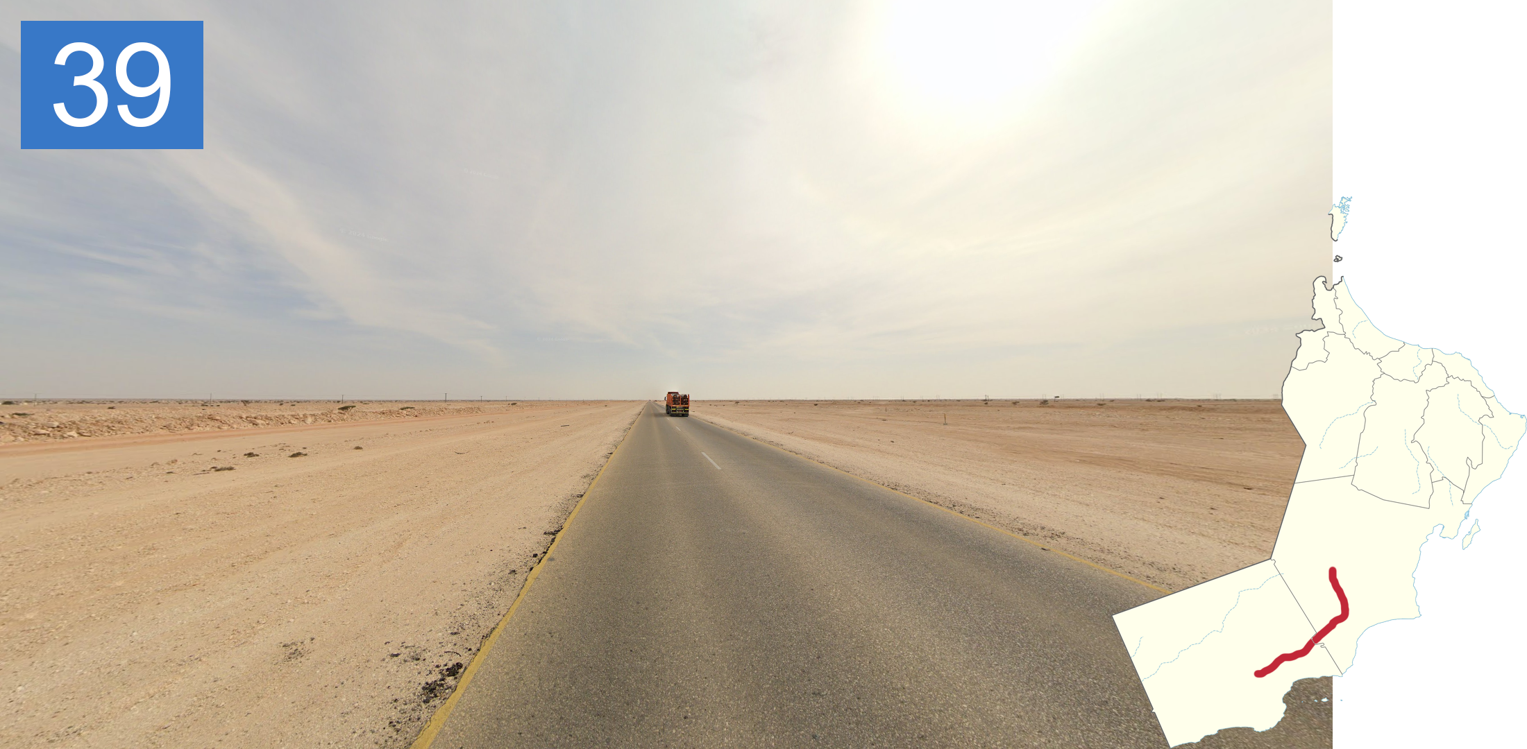
Road 39 is also one of the more generic roads. Probably the best way to recognise it are the narrow, or even non-existent shoulders. The western parts can get quite hilly, but overall, the desert landscape is flat.

Coastal Road 41 features one of the sandiest landscapes in Oman, with very light sand all around. The coast is sometimes visible in the distance. On the north-to-south stretch, you can see a distant ridge to the west.

The western stretch of Road 41 has wide shoulders similar to Road 31, however, the more northwest-bound angle along with the reddish soil should tell them apart. The eastern half has cloudy coverage.

Road 42/49 east of Salalah is a scenic coastal road that features a lot of light-coloured tall rocky cliffs. The coast is also often visible.

Just south of Shalim, you’ll find a stretch of overcast coverage, along with a power line to the west of the road, but only north of the plateau.

North of Shalim Road 42 turns into a very wide unpaved road, with the soil being quite light in colour. You’ll sometimes see oil drills in the distance along this stretch.

The road southeast of Ubar has a general northwest bound angle, along with a power line to the left of the road. You will often see signs of life in the form of farms or buildings on this road.
NOTE: Don’t mix this up with the 37, which has a similar angle, but is more desolate and can have sunset coverage.

Road 43, also south of Ubar, is unpaved and features sunset coverage along with a dust trail behind the car.

West of Ubar, the 43 and the unlabelled road west of it are still unpaved but now have a power line to the north. The desert landscape has an orange tint to it.

The road north of Al Awaya features a desert landscape with dark grey soil, which is not common in the south. The road itself still has the orange tint characteristic of southwest Oman.

The unlabelled road northwest of Ubar can be recognised by the small white markings between the dashes.

The unpaved road north of Al Mazyunah, near the Yemen border, has a north-north-west bound angle, and the desert has sandy, red-tinted sand, which still has some shrubbery around. You can see some hills in the distance. The southwards driving direction and sunny weather can be used as confirmation.

Just west of ميتان, only labelled in Arabic on Google Maps, literally translating to methane, there is a stretch of road, which has a uniquely light-coloured pavement. To the north, you can see sand dunes.

Roads 45 and the western stretch of 39 both feature a similar slightly hilly desert landscape, sunny weather, and a general east-to-west direction. What makes them unique is the light-coloured shoulders the roads share, though it is most pronounced on Road 45. The roads also mostly have a faded white middle line. To tell the 45 and western 39 apart, look at the sun, which is overhead on the 39, but to the west on 45. The section north of Mudayy is also the 45, but unlabelled on Google Maps.

Most of Road 45 south of Mudayy is unpaved and goes generally north to south, through some very rough hilly terrain. The soil is light and very rocky. Beware that the southernmost stretch is paved.
GeoGuessr’s own official maps are not very good, for a variety of reasons. Plonk It recommends the following maps instead: