
Nepal
Step 1 – Identifying Nepal


Nepali licence plates are typically fairly long, with the most common design being white. Private vehicles use red plates, while public vehicles use black ones.

All of the road coverage in Nepal was taken with what’s commonly referred to as “shitcam”, which is a low-quality camera that can typically be recognised by the brownish colours and often, but not always, by a large circular blur covering the Street View car.
NOTE: Shitcam coverage is also very common in India and can rarely be found in Bangladesh and Sri Lanka.

Nepal drives on the left side of the road.

Nepal uses the Devanagari script, which can be recognised by the line going through the top of each word and the straight vertical lines found in the majority of all letters.
NOTE: The characters ङ and especially ङ्ग are much more common in Nepali than in Hindi/Marathi. It is also quite common to find native Devanagari numbers on signage in Nepal, which is very rare in India.

Nepal typically uses square concrete poles in the flat areas, and thin metallic poles in the mountainous regions. The poletops vary, but it is often some kind of trident.
The concrete pole with a trident pole top and triangle supports is unique to Nepal. Another common pole almost unique to Nepal is a concrete square pole with 2 vertical insulators on the sides with a wide gap between them. Other poles can often appear very similar to poles in India.


Nepal mainly uses black-and-white striped concrete bollards that often have a red marking on the top. The amount of stripes vary from 3 to 5.

You will see flat agricultural areas in the south as well as high altitude mountain roads in the northern half of Nepal.

Most buildings are either colorful blocky multi-story structures or small houses with painted concrete, red brick, or thatched looking walls, with either a tiled or tin roof. As part of the building facade, you will often spot triangle shaped decorations.

Nepal uses black-and-white striped signposts.
NOTE: Within South and Southeast Asia, India, Bangladesh, Sri Lanka and Malaysia also use black-and-white striped signposts.

This type of white-painted buddhist stupa, sometimes with painted eyes on the sides, are only found in Nepal.

Districts can show up on addresses, often in English as well.

The area in the far south close to the Indian border is almost completely flat, while the central and northern parts are very high altitude and very mountainous.

The western hills can be recognised by the dry landscape, with a lot of exposed hillsides lacking vegetation.

Areca Palms can be recognised by their very thin trunk and a small crown. They are mainly found in the southeast.

Canola, a crop with bright yellow flowers, is mostly found in a few southern pockets in the western half of Nepal.

Chir Pines, which can be identified from their generally smooth-looking conical or spherical crowns with very long needles, are found everywhere in the mountains, but are much more common in the west, and near Kathmandu.
NOTE: The eastern region is generally greener than the west.

Grass with white and fluffy-looking tips is most commonly found just southeast of Kathmandu.
While it can be found in most of the country, it usually won’t look as white and fluffy outside the dark red coloured region.

Japanese cedar trees, which are only found in far eastern Nepal, can typically be recognised by their significant height combined with their narrow, fluffy-looking crowns.

Tea Plantations are also only found in far eastern Nepal. Both in the mountains, and in the flat region.

Rounded roof tiles are most common in the flat regions south of Kathmandu, but are also prevalent further west.
NOTE: Don’t mix this up with the half-rounded tiles, which are part of the hint below this.

West Bengal style roof tiles, which are more organised and have small diamond shaped protrusions, are most common in the far west flat region. This hint also works for the half-rounded tiles

Flat square shaped stone tiles that are grey in colour are common south of Kathmandu, more specifically around Birgunj and Janakpur.
NOTE: Neat, square, stone tiles are not found in parts of India that tend to look similar to Nepal.

Rectangular tiles that are less organised in shape and placement are common in western mountain towns, but can also be found towards the center of the country.

Roofs made from sheets of corrugated metal are most common between Birgunj and Janakpur.

Roofs that have a railing along the sides of the roofs, usually made of dark concrete, are found in some parts of western Nepal. They are most common in the Tulsipur valley, where the railings sometimes have a stair shape. The easternmost region where they’re found is the plains by Kawasoti. The westernmost regions often have lower quality “railings”, sometimes consisting of a few sticks.

Gable ends decorated by carvings of gods, goddesses, and other religious symbols, usually painted in a golden colour, are mostly around Kawasoti, west of Bharatpur.

Fences of varying build quality, made of mainly sticks, are most commonly found in the eastern plains of Nepal.

In the far east, you will mainly see roofs made of sheet metal with a triangular "window" just below the ridge of the roof, and an outwards sloping section below it.

Large hip roofs made of sheet metal with a small protrusion just below the ridge are found around Biratnagar in the east.

Similar to the above hint, hip roofs made of sheet metal with an even smaller protruding piece of metal at the ridge are mainly found west of and around Biratnagar.

Mosques are concentrated in a few muslim majority spots in southern Nepal.
In the east, just around Janakpur.
In the east, just around Birgunj.
In the west, just around Nepalgunj.
In the east, around Biratnagar and west of the Koshi river.

Small round clay huts with thatched roofs are mainly found around Birgunj.
NOTE: These are also common just over the border in India.

Poles with a cross attached near the top are common in the east.

In Kathmandu, you’ll find poles with an asymmetrical crossbar, which has a triangular attachment on top of it, as well as a support bar below it.

While the most common water tank colours in Nepal are green and black, which are found everywhere, yellow ones are mainly found in the east.

An orange google car can be found around:
Nepalgunj in the west
Madi, south of Bharatpur in the central south
Biratnagar in the east
Birtamod in the far east.

An orange orange car with a blue ribbon on the front is found around Biratnagar.

A blue car is found around:
Pokhara, under the Nepal label
Birgunj, southwest of Kathmandu
Malangawa, near the Indian border southeast of Kathmandu.

If the blue car has an antenna, you will be around Pokhara.

A white car can be found in the following areas:
Around Butwal, southwest of the Nepal label
On the H10 going to Pokhara
On the H04 east to Kathmandu
On some roads near Kathmandu
Northeast of Birgunj, southwest of Kathmandu
From Janakpur to Lahan, southeast of Kathmandu
Around Itahari, in the east.

A car with a black spoiler is found just around Janakpuj, southwest of Kathmandu.

A regular grey car can be found around Kathmandu, and to the southeast, around Lahat.

A blocky grey truck can be found east of Birgunj and just south of Kathmandu.

A grey car with a visible backlight can be found in the following areas:
Around Pokhara, under the Nepal label
Around Kathmandu
North of Malangawa, near the Indian border southeast of Kathmandu
East of Itahari, in the east.

A red car, that usually has a long antenna, can be found in Kathmandu, and north of Janakpur, which is southeast of Kathmandu.

Some roads north of Siddhicharan, in eastern Nepal are unique due to the high elevation hills with dark green rhododendron bushes growing in abundance. The bushes have red flowers which can be hard to see.

This foggy and gloomy road hosts the only natural forest dominated by east himalayan fir. You can recognise it from all the tall dark trees present around the road. It is located just northwest of Bhimeshwor Municipality, east of Kathmandu.

This sketchy yellow/orange dirt road can be recognised from the high elevation landscape with the high elevation oaks. It can be found northeast of Phungling in far northeastern Nepal.

This dirt track in a northwestbound valley can be recognised by the snowcapped mountains to the northwest. You can find it north of the Khaptad national park in western Nepal.

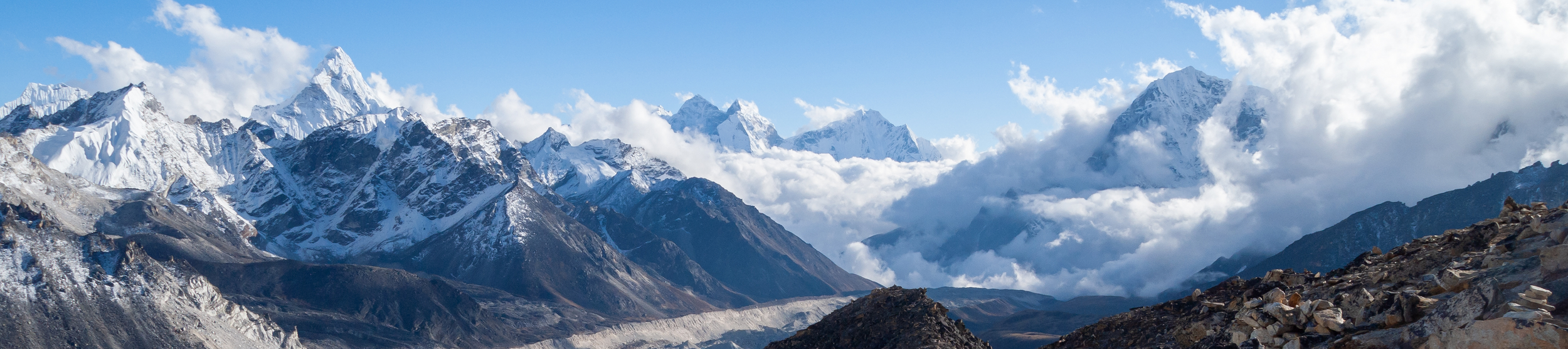
Trekker coverage in Nepal is limited to the northeast of the country, in the general area southwest of Mount Everest.

Green forests and trees are found in the southern parts of the Nepalese coverage.

Barren mountain trails are found in the northern parts of the coverage.

A lot of the coverage in the vicinity of Namche Bazar can be summarised as being sunny, with the trails going close to the treeline, meaning you will be either near the top of or just above a forest for most of this coverage. You will generally see barren or snowy mountains in some direction.
Important note: The compass in Nepal is generally not very reliable. Thus, a compass will only ever be included in a picture for which the compass is at least mostly correct.
Settlements

Namche Bazar is by far the largest and most densely populated settlement with coverage in Nepal. There is also some coverage looking down on the town.

The southernmost coverage in Nepal is situated in the town of Lukla, which can be recognised by the narrow street with relatively large buildings, combined with the extremely dark coverage.

Khumjung village, situated just north of Namche Bazar, can be recognised by the jagged mountain towering above the village. Almost every house in the village has a green roof.
Beware that there is a label for Khumjung further north, which is not close to the village.

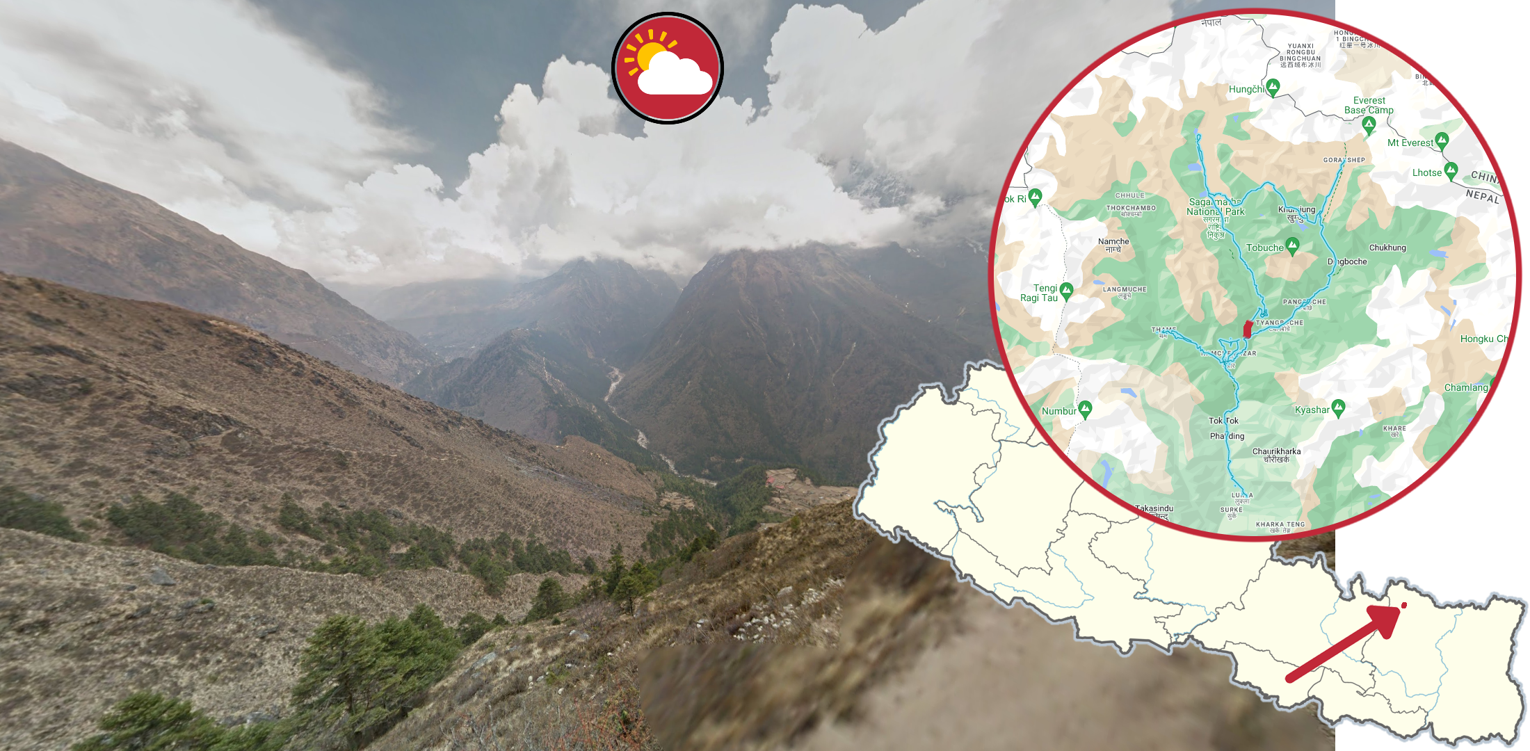
Pangboche is a fairly large settlement with fairly bright coverage. The surrounding landscape mainly consists of forested mountains nearby and some taller mountains in the distance.

Phorste is a fairly scarcely built settlement with a massive recognizable mountain close by. There are a lot of dead-looking trees surrounding the village.
Lukla - Namche Bazar

Around the southern tip of the Nepalese coverage, you will get this dark, overcast coverage inside a forested valley.

North of Phakding you will get more overcast coverage in the same forest valley, however here the coverage is far brighter.
The coverage from Monjo up to Namche Bazar is also within the same valley, however here the coverage is mostly sunny and bright.
Namche Bazar - Thame

The valley by Thamu can be recognised by the generally forested mountainsides, combined with the angle of the valley, going northwest to southeast.

Next to the village of Thame you can see this snowy, and shining bright mountain range.
Namche Bazar - Gokyo
Northeast of Namche Bazar, you can find this semi-green river valley with clouds covering all mountains surrounding it.

On a section north of Phorste, you get a view of the mountain Tobuche, covered in a blanket of clouds.
Further north, the cloud blanket is replaced by small, spotty clouds somewhat resembling smoke coming out of chimneys.

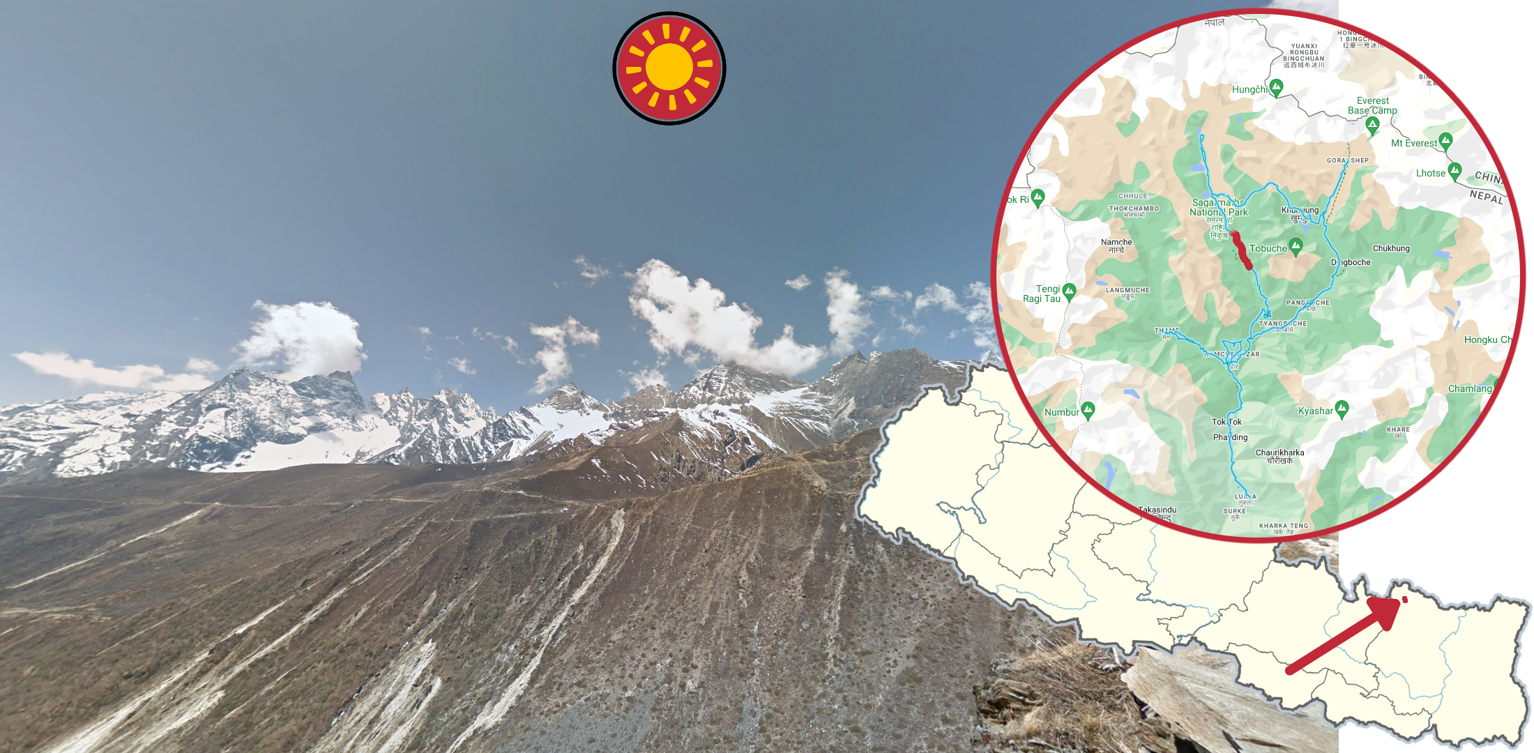
Even further north, the clouds disappear completely, and you get a clear view of the Tobuche peak.

Leaving Tobuche behind, you will find this small, ice-covered lake, right by Gokyo, with jagged mountains as a backdrop.

North of the icy lake, you reach a barren landscape, with a trail going to the north-north-west.
Gokyo - Lobuche

East of Gokyo, you reach this dried out glacial valley, with bright grey rocks as far as you can see.
NOTE: This valley can less commonly be seen from the trail north of Gokyo.

East of the glacial valley, you get to a somewhat red-coloured, rugged mountainside right next to the trail.

Leaving the red mountainside behind, you enter a somewhat U-shaped valley, going firmly upwards.

Above the U-shaped valley, you get a view of this spiky mountain range. While there are some clouds around the peaks, they are mostly clearly visible.

As you lose sight of the spiky mountains, you cross over a glacier, which is the largest patch of snow covered ground with coverage in the country.

The area east of the glacier can be recognised by the many irregular clouds spread across the sky and covering various mountain peaks.

Further along the trail, you get this stunning view over Tobuche from the eastern side. The mountains get increasingly covered in clouds to the west.

Closing in on the final trek toward Everest, you get a view of this wide, high-altitude river valley.
Namche Bazar - Dingboche

Slightly east of Namche Bazar, you can find this very overcast trail following the mountainside. There are still some trees around, and the trail is noticeably higher above the valley than other overcast sections with trees.

East of the POI called ‘Deboche’, you get this very overcast forest coverage. The dirt here is very bright and sandy, which can help differentiate it from the southern trail.

You can recognise the trail between Pangboche and Dingboche by the massive mountains, combined with the sun looking somewhat hazy.
Trail to Everest

North of Dingboche, you reach a high-altitude valley with very low clouds covering the sky and most of the surrounding mountains.

Closing in on Everest, you get this completely barren landscape, with the trail going to the north-north-east.

Reaching the endpoint of the coverage, you finally get a stunning view of the world's tallest mountain, Mount Everest.
GeoGuessr’s own official maps are not very good, for a variety of reasons. Plonk It recommends the following maps instead:
AI Gen Nepal (map link) - AI generated map with 100k+ locations.