
Kyrgyzstan


Licence plates in Kyrgyzstan have a red strip on them.
NOTE: Licence plates with red strips can sometimes be seen in Albania and very rarely in the UAE.

Kyrgyzstan can be recognised from the silver car and four bars that are visible. All coverage is Generation 3.
NOTE: No other country with a similar landscape has a similar Street View car.
The Kyrgyz script is similar to Russian. However, the Cyrillic script used for Kyrgyz includes additional characters not found in Russian Cyrillic, such as:
Ө
Ү
Ң

All of Kyrgyzstan was covered during the winter months, so many of the trees will lack leaves, the landscape will be quite drab, and you can see snow in many parts of Kyrgyzstan.

In Kyrgyzstan, you will often see trees and concrete poles that are painted white on the bottom.

Kyrgyzstan uses these simple white bollards with a diagonal black stripe near the top.

These kilometre markers with a red-and white triangle pattern are unique to Kyrgyzstan.

The majority of Kyrgyzstan’s population is Muslim. Hence, you will see a lot of mosques throughout the country.

The coverage in Kyrgyzstan is very limited. So learning which roads are covered will help you improve a lot.
You can click on the image to enlarge it.

Learning which direction the Google Car is driving on most major roads will help you narrow down your options when guessing.
You can click on the image to enlarge it.
Car mirror metas

You can use the Google car’s mirror to region-guess Kyrgyzstan. In the southern region, less of the road is visible on the mirror. The car’s reflection is more diagonal. For comparison, this is what it usually looks like.

Within this southern region, west of the roundabout that takes you up to Jalal-Abad, the mirror will have a varying degree of dirt on it.

If you see a small black dot on the Kyrgyzstan car mirror, you will be in this region.
Other basic region-guessing tips

Divided roads are mostly concentrated in and around the capital, Bishkek. A major divided highway runs from Bishkek to Balykchy in the east.
NOTE: The cities marked on the map also have at least one divided road.

Lake Issyk Kul is the biggest body of water in Kyrgyzstan. You will often be able to spot it on the roads north and south of the lake. Sometimes it will be obscured by buildings or trees, but the lack of any mountains in the direction of the lake will be a good clue.
NOTE: There are two other significant bodies of water that can be seen from the road: the Toktogul Reservoir and Lake Song-Kul. With a bit of practice, you can reliably distinguish these from Issyk Kul however.

These northern roads have a considerable amount of snow, and the sky is generally bright.
The individual sections of these roads are discussed in more detail in step 3.
NOTE: There is also snow coverage in the south. However, you can use the mirror to distinguish these roads.
Cities
Bishkek and surroundings

As the capital city of Kyrgyzstan, Bishkek is by far the most developed city, featuring many taller multi-story buildings you would not see elsewhere. And on the outskirts, you can see fancier buildings as well. There are also mountains south of Bishkek, but these can be hard to see at times.

You can find urban snow coverage in this region of Bishkek.

The coverage south of Bishkek is generally a bit hilly, and you will see the snowy Tian Shan mountains to the south. And as Bishkek has the most polluted air of any city, there will usually be visible smog to the north.

These towns east and west of Bishkek feature these colourful poles with yellow, green, white, and sometimes red on top.
NOTE: Sokuluk will not have the red paint on top.
Towns and cities with the southern mirror

Osh is the second-biggest city in Kyrgyzstan. It is one of several towns that has coverage with the southern mirror. This allows you to easily distinguish it from Bishkek.
The weather in Osh is fairly good, with some clouds, but never fully overcast.
NOTE: Jalal-Abad, the other big city with the southern mirror, will always have very overcast coverage.

You can also distinguish Osh from Bishkek by looking at the trees: most still have their leaves.

In the centre of Osh, you can see these unique mountains with radio masts on top of them.

Jalal-Abad is the third-biggest city in Kyrgyzstan. Like Osh, its coverage has the southern mirror.
You can recognise it from the extremely overcast coverage, with no gaps in the clouds. This allows you to easily distinguish it from Osh, which has better weather.
To the east, you can see this slightly snowy hill.

Arslanbob is a snowy town north of Jalal-Abad, with hills and mountains all around. As the town is located in the mountains, you can see a lot of elevation change inside the town.
NOTE: The town also features the southern mirror.
Uzgen is a slightly snowy town between Osh and Jalal-Abad, which features overcast coverage.
NOTE: The town also features the southern mirror.
Other recognizable towns

In Talas, most poles are painted white on the bottom, and feature red and yellow stripes.

Karakol is a city located between snow capped mountains to the north and south. The coverage in the city is sunny, and you can see melting snow on the ground.

Naryn features a steep orange ridge to the north, and big snow capped mountains to the south.
Roads
Important notes:
This section attempts to describe every major road, as well as some of the minor roads, in as much detail as possible. However, despite our best attempts, not every stretch of road is included.
The following tips use a road numbering system different to that of Google Maps, because those are incorrectly mapped. You can find the correctly mapped roads on OSM. This is done for the sake of organization; in-game it is advisable to rely on town names as reference points.
EM-04

The EM-04 is a major road that runs from Bishkek to Osh.
Includes 10 tips.

You can notice a distinct sunset on all the coverage from Sokuluk to Kara Balta.
NOTE: This section of road features the Black Dot Mirror.

Here, you will see the Tian Shan mountain range to the south. The landscape is otherwise flat. The further away from the mountains you are, the foggier they seem.
NOTE: This section of road features the Black Dot Mirror.

The mountains here can be characterised by steep rocky cliffs that can have a slight purple or red tint to them. Not much vegetation grows on these mountains - only some grass and shrubs. A small river also runs alongside the road. You can also spot these brown metallic electricity pylons and curved concrete guardrails on the sides of this road.
NOTE: This section of road features the Black Dot Mirror.

On this long stretch of road, you will see plenty of snow all around you, except on the road. The Landscape is generally hilly, except the northeastern and southwestern parts, which are in the mountains.
NOTE: Most of this section features the Black Dot Mirror.

This section of road goes through mountains that have rocky cliffs. These mountains are a habitat for lots of spruce trees that grow on the cliff sides. A more diverse selection of trees grows next to the river that follows the road. You can see that some mountains still have snow on the peaks. Most signposts along the road are coloured blue.
NOTE: The southern section of the road features more rocky cliffs that cannot sustain any trees.
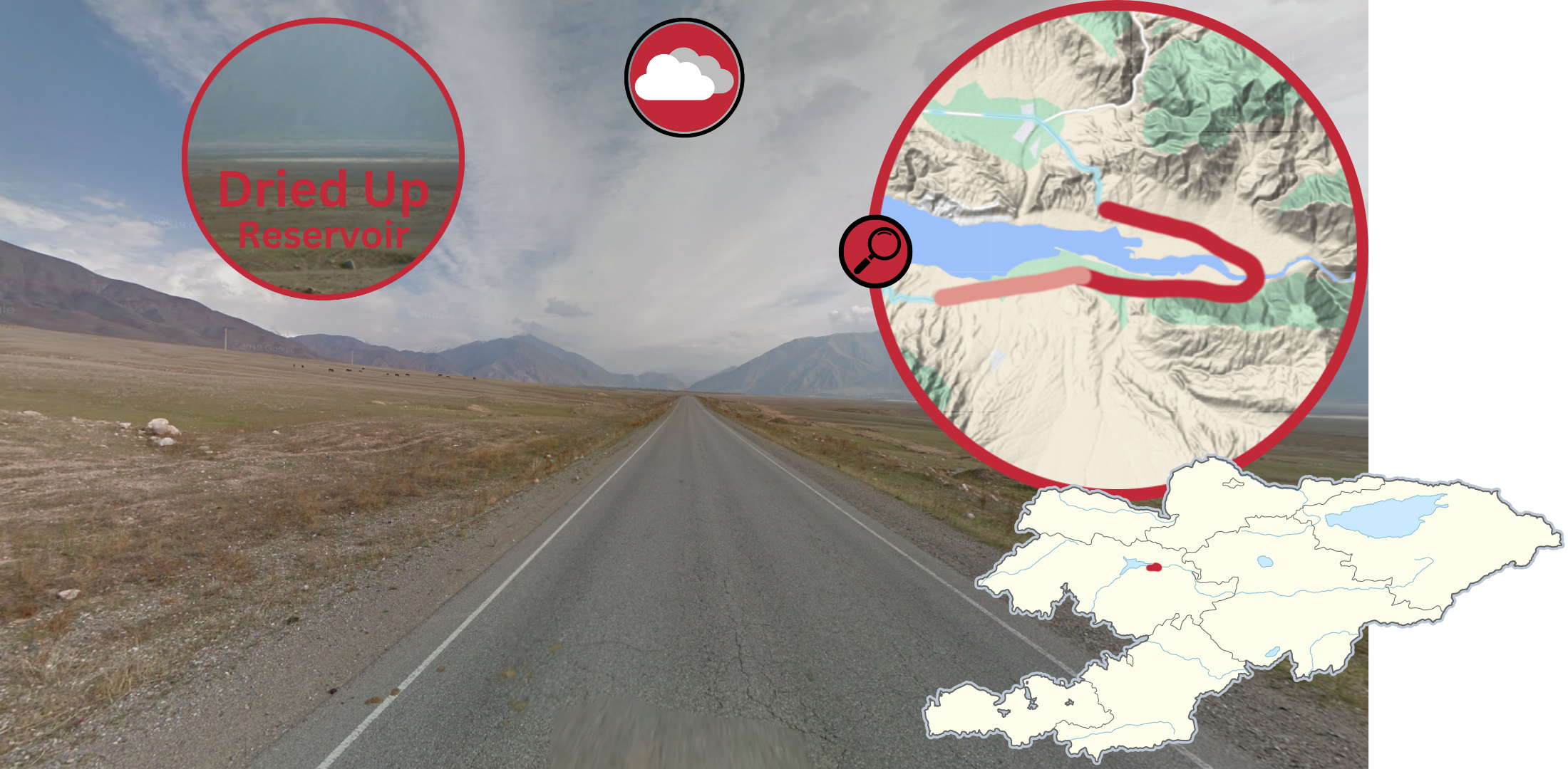
You can see the mostly dried up part of the Toktogul Reservoir either to the south or north of the road. There are taller mountains quite close on every side. The northern half is more desolate, while the south features more vegetation and buildings as well.

You will usually see the Toktogul Reservoir north of the road in this section. It now resembles an actual lake. The landscape is generally hilly, especially to the south.
NOTE: The road is in better condition than the one south of Issyk Kul.

The road then runs through a river gorge, with large, rocky mountains on both sides. It features overcast coverage. A sizable river (the Naryn) is usually visible to the north, next to the road.

This southern region has a lot of agriculture and a lot of vegetation on the sides of the roads. The region is generally flat, but the road is very close to the hills that are usually to the north or east. The gaps in the minimap indicate exceptionally hilly spots.
NOTE: This section of road features the Southern Dirty Mirror.

In the south, this stretch of road northwest of Uzgen is characterised by overcast coverage and lots of snow.
NOTE: This section of road features the Southern Mirror.
EM-11

The EM-11, which shows up as A365 on Google Maps, runs from Bishkek down to the Chinese border. The coverage ends here.
Includes 10 tips.

The beginning section of the divided EM-11 has this grassy median up until Khun-Chi.

From Khun-Chi to the intersection east of Tokmok, the road uses these road lines with a wide gap as a median.

The gap in the road lines gets thinner east of that intersection up until this intersection east of Kemin.

From there onwards, concrete barriers are used as medians.

The road then becomes undivided. This section south of Balykchy is extremely dry, with the landscape mostly consisting of small shrubs, unless you are next to the Chu river. To the north, you can spot these mountains that have clouds hovering above them. Otherwise, there are no clouds in this region.

Further up the road, you enter a dry valley with mountains flanking both sides. There is barely any vegetation - just some shrubs close to the ground. The river next to the road brings some more greenery to the area. In the southern half of this section, you can see this slightly snowy ridge to the north.

Going further south, you will reach this next valley, which seems equally dry, but the mountains are more rocky and have trees growing on them. The road now has very bad pavement, and as such you can see dust clouds.

Once you get out of the valley, you will notice this area is more vegetated, has more buildings, and more animals on the now grassy fields. The landscape is still hilly, with bigger mountains to the north, south, and west. The southern mountains are especially distinct, with them being covered in snow. The hills immediately north of Naryn can get very dry, but look out for snow that you can see in the shade.

The mountains and hills south of Naryn have a unique combination of snow and red soil that make them very distinct.

The At-Bashi Valley has a very distinct mountain range, which you will see to your south from any section on this road. To the north, you can see scattered mountains that do not form a uniform ridge. There is also a big set of hills to the west.
EM-09

Road EM-9 runs from Balykchy to Karakol in the far east. On many parts of the road, you will be able to see Lake Issyk Kul to your south. The car drives towards the east (and in the last section towards the south).
Includes 3 tips.

The section from Balykchy to Cholpon Ata is sunny, with mountains to the north, and a lake to the south.

The section east of Cholpon Ata appears overcast, with mountains to the north, and a lake to the south. Tall tree rows on either side of the road is a common sight.

The vertical stretch of road north of Karakol is mostly flanked by tall tree rows on either side. There are also tall snowy mountains to the north and south.
NOTE: The weather changes here, around the midpoint of the road.
EM-10
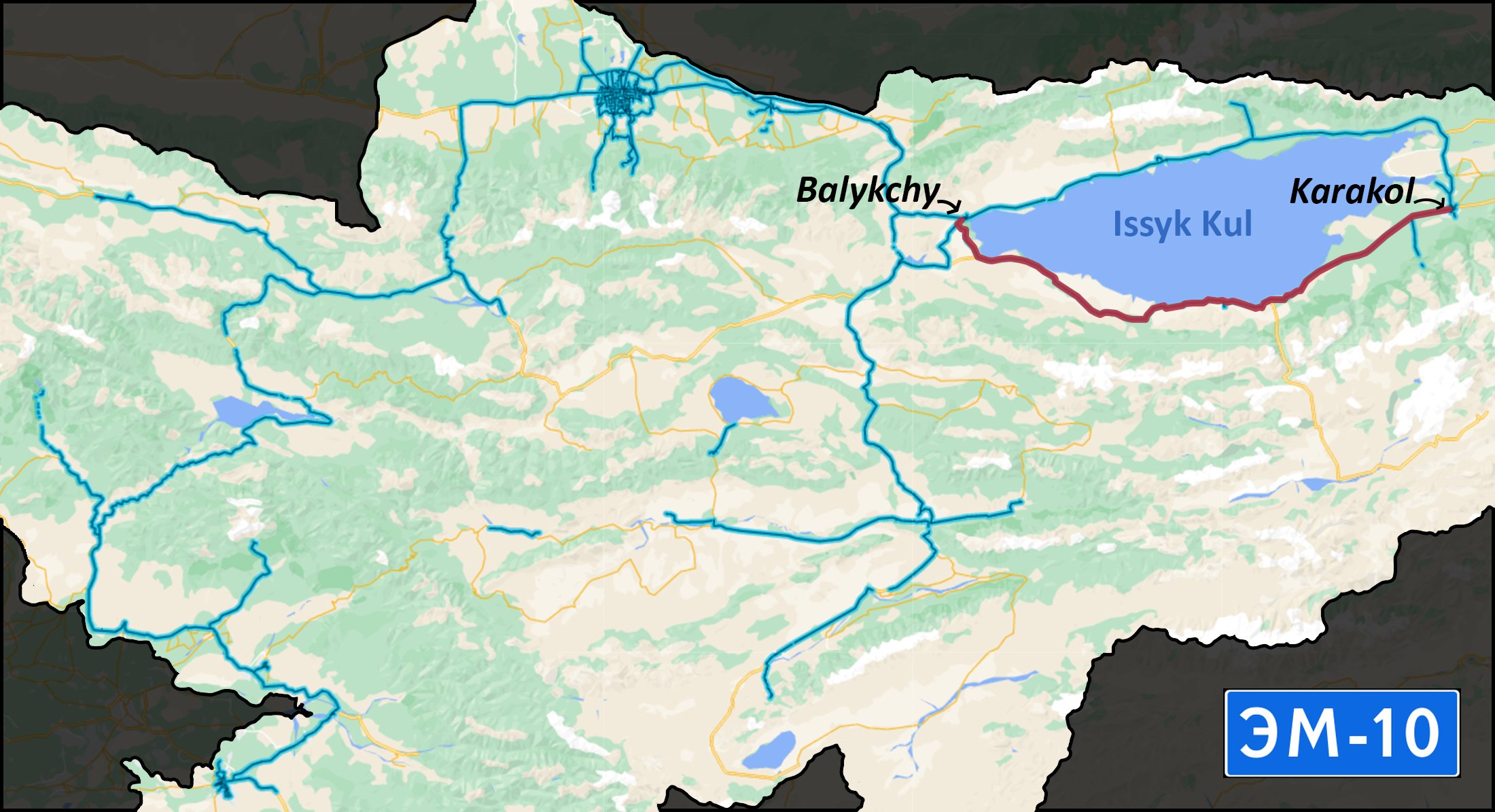
The EM-10, which also shows up as A363 in Geoguessr, is a beautiful road connecting Karakol to Balykchy. Here, you will often see Lake Issyk Kul again, but this time it is visible to your north. The car drives towards the west.
Includes 5 tips.

On the road west of Karakol, you will see a lot of vegetation on the sides of the roads, and long expanses of green and yellow fields beyond them. You will usually be able to see the Tian Shan Mountain Range in the distance to the north. There are big mountains to the south as well, with smaller hills before them.
NOTE: The weather is completely clear east of this intersection.

You will almost always see the Issyk Kul lake, and the Tian Shan mountains on this section. The soil here is sandy and rocky.

The section west of “Fairytale Canyon” has distinct sunset coverage.

You will see a lot of mountains and hills to the south here, but only some hills to the north, with seemingly nothing behind them. You might even see Issyk Kul behind them. There is still a lot of sand on the sides of the roads.
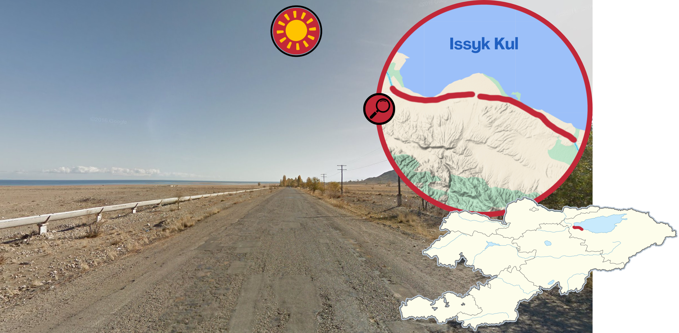
The landscape around the western end of Issyk Kul is drier than the east. The lake itself and the southern hills are further away from the road as well.
EM-17

The EM-17 runs southeast of Talas.
Includes 2 tips.

This section of EM-17 is very snowy. The hills and mountains around the road are almost fully covered in snow. Unlike the other snowy roads, this road is often covered in uncleared slush or melted snow.
NOTE: This section of road features the Black Dot Mirror.

Going further west, only the hills to the south will have snow on them. The landscape is generally dry, with hills to the north and south of the road.
Most of this section features the Black Dot Mirror.
EM-13

The EM-13 is a small gravel road, which sadly only has small bits of coverage.
Includes 2 tips.

The road going east of Kazarman is an unpaved gravel road, between two hilly ridges on either side. The ridge to the north is further away, and has a bigger set of mountains visible behind it. The mountain ridge has a unique mountain that towers above the rest.

The eastern side of EM-13 closely resembles the road going west of Naryn. (See tip below) This road, however, is an unpaved gravel road in the middle of the Naryn valley, so the hills to the north are now closer. The Landscape is filled with bushes, shrubs, and grass.
NOTE: The one town in the region can be recognized by these white-and-red fences with a white diamond pattern in the middle.
M-072

This road going west of Naryn is situated south in the dry Naryn valley. You will typically see hills close to the road on the southern side. There are also bigger mountains not too far behind. While to the north, there is a wide plain, with hills and mountains in the distance. Many parts of the road also have a pavement with a salt and pepper-like quality.
M-068

The road going east of Naryn is also in the Naryn Valley. Here you will also see hills close to the road in the south, and then further away to the north. The plains north of the road are however smaller. This side is also more built up, except the road, which is unpaved at certain parts. Here, the hills south also have small amounts of snow on them.
M-082

The M-082 is a unique road, with only a small section being covered, from the shore of Song-Kul to the mountains right south of it.
Includes 2 tips.

Song-Kul is the second major lake in Kyrgyzstan. The surrounding area features dry rolling hills, with patches of snow. The only covered road is made of gravel.

The road in the mountains south of Song-Kul is the only unpaved road this high up in the mountains. You can see the clouds below you, down in the valleys below. The mountains have rugged peaks, and snowy cliff sides. Many of the mountains also have spruce trees growing on them.
M-118

The M-118 takes you from the resort town Arslanbob down into the fertile Fergana Valley.
Includes 2 tips

On this road, you should be able to see the Kara Darya river to the east in the valley below the road. The region is generally hilly and green. To the north, you can see some low-lying mountains in the distance, they have some snow on them. The hills east of the river have snow on the top as well.
NOTE: This section of road features the Southern Dirty Mirror.

There will generally be some snow on the ground on this road. You will see more snow depending on how north you are. You will often see the massive Gora Babash-Ata mountain to the north.
NOTE: This section of road features the Southern Dirty Mirror.
M-107

The M-107 is a pretty road connecting Taskomur to Kerben. Only the first half is covered.
Includes 2 tips.

This section of M-107 is dry and rocky. There are a lot of mountains around, but this one ridge specifically can be seen from most of this section.
HINT: This is what the ridge looks like from further away.

Going further west, you will encounter a very hilly landscape. The landscape features a lot of vegetation - tall grass, trees, bushes. This road uses these concrete barriers as guardrails, notice the cement above the gaps.
The general southeast to northwest driving direction on this road is also worth noting.
Arkit Road

This road going all the way to Sary-Chelek lake is one of the most unique roads in Kyrgyzstan.
Includes 2 tips.

This valley is full of vegetation. This area also has a lot of buildings and fences near the road. Most of the road is in poor shape, with it being unpaved and potholes littering parts of it. To the north, you can see some darker clouds, and closer to Arkit, the weather will get cloudier, and there are more dead trees.
The south to north driving direction on this road is worth noting.

This section near Arkit has a lot of snow everywhere and low broad leafed trees all around. This already unique landscape paired with the south to north driving direction makes it very easy to recognise.
Other smaller roads
This section of the M-010 is surrounded by beautiful spruce covered snowy mountains. Some snow has also gathered on the sides of the road.

This rocky dirt road going to Chunkurchak is mostly high up in the snowy hills south of Bishkek. Some of the soil here has a red tint to it. On the northern part of the road, you can only see the snowy hills to the south. Also pay attention to the red-and-white bollards on the sides of the roads.

There is another road with coverage to the east of the Chunkurchak road: it goes through a very rocky valley, with a variety of plants growing on the mountainsides, of which only some have small amounts of snow. You can also see some snow in the valley, and more so towards the south.

You can easily recognise this side road, labelled as A367 on the map, from the snow covered mountain ranges in every direction. The sun to the south is almost blinding.
NOTE: This section of road features the Black Dot Mirror.

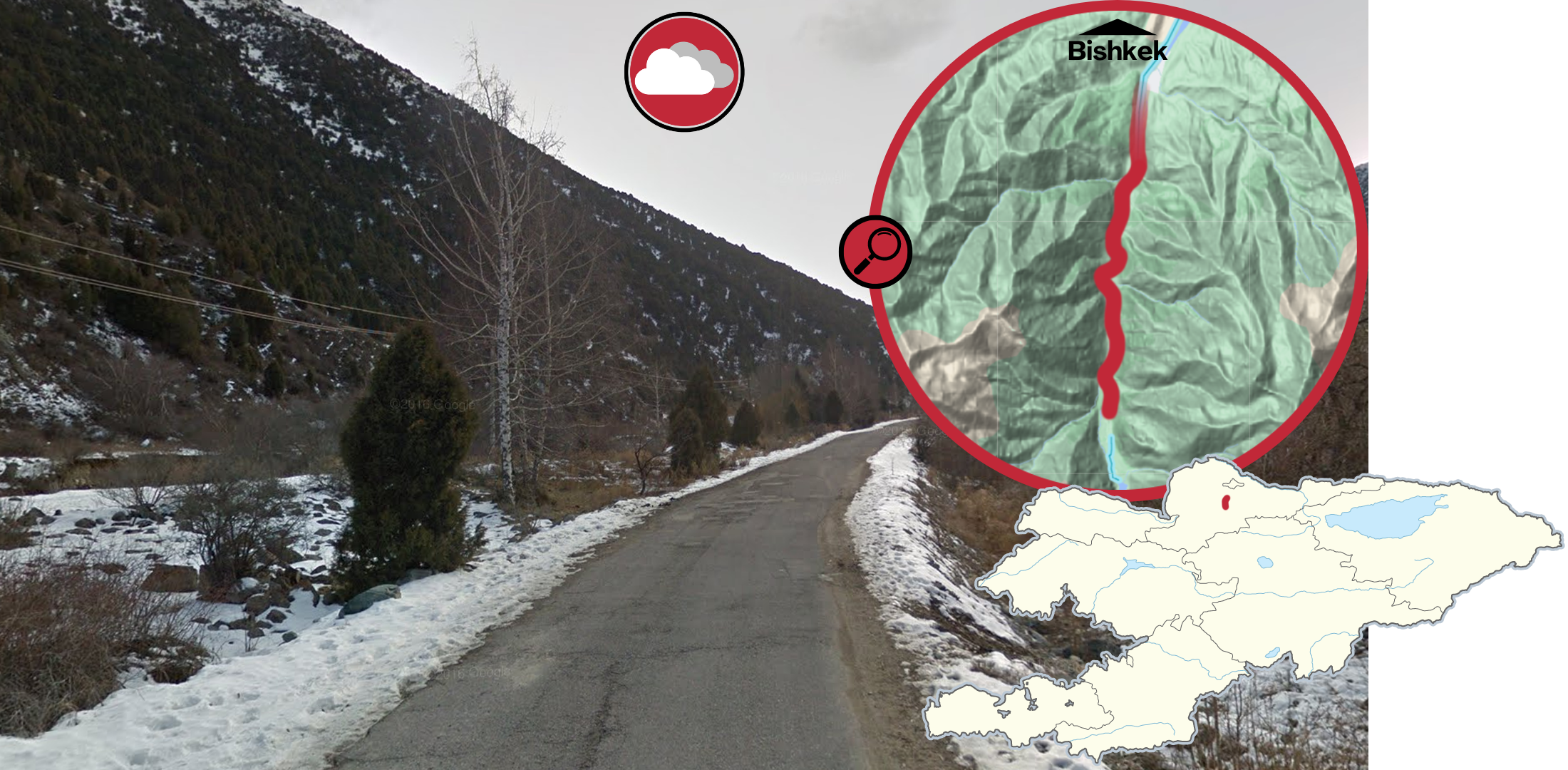
This divided road north of Bishkek, that leads up to the international airport, uses unique yellow-and-black curbs on the median, which consists of mostly grass. Some sections have small planted trees, and poles with red-and-yellow paint on the bottom. The horizontal section west of the airport has a lot more trees.

This slightly northeast-bound road north of Bishkek can easily be recognised from the sunset coverage.
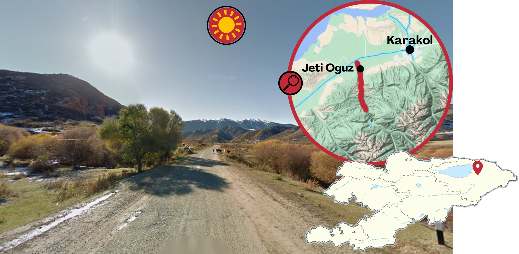
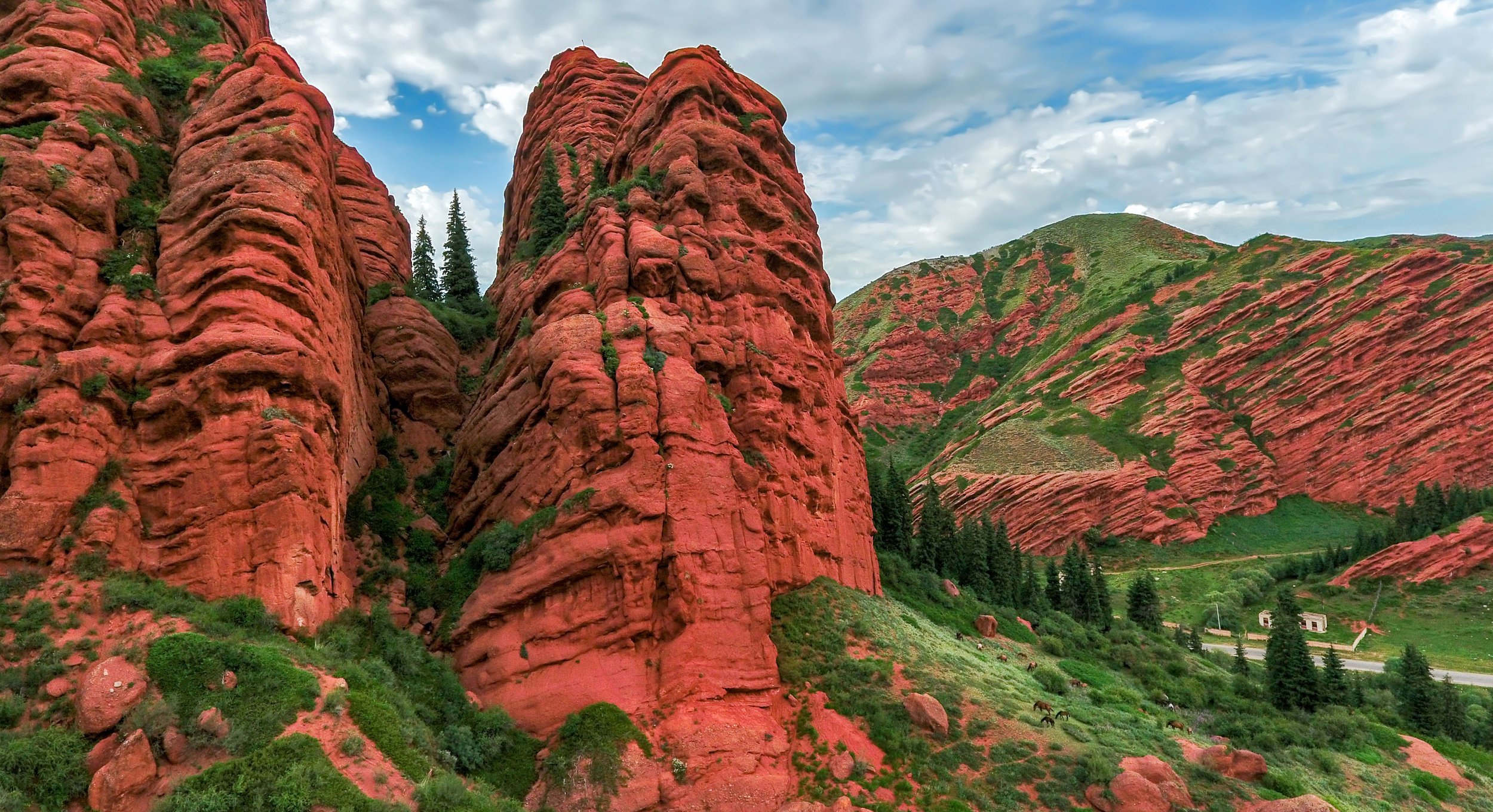
The road south of Jeti Oguz goes through a valley. The general landscape in this valley is very green by Kyrgyzstan standards, there are plenty of trees and bushes growing in the valley and on the hills. You can see small patches of snow still on the ground. From most of the valley, you can still see the Tian Shan mountains to the north, and other snowy mountains to the south. The valley also contains these unique orange rock formations.

The road north of Grigorievka goes through a stunning river valley. This is one of the most unique roads in Kyrgyzstan. You can easily recognise it from the spruce covered mountains in this rocky valley. The lack of snow is also notable.
The northern half of this road is on an open rolling field with pine forests scattered around.

There is a side road north of the Orto Tokoy Reservoir that has very broken coverage. This road is well maintained, and it passes through dry mountains. The only vegetation around is grass and shrubs. To the west, you can see this mountain which has little snow left. To the north, the mountains are dark, similar to silhouettes, and on the southern portion of the road, you will see the reservoir.

This remote gravel road southwest of Naryn passes through a dry and desolate valley. Despite the river, there is nothing but some shrubs on the ground. Many of the mountains in the valley have steep, rocky cliff sides. You will also find snow here, but more so in the south.
GeoGuessr’s own official maps are not very good, for a variety of reasons. Plonk It recommends you play these maps instead: